Shom chooses Navsight solution for bathymetry
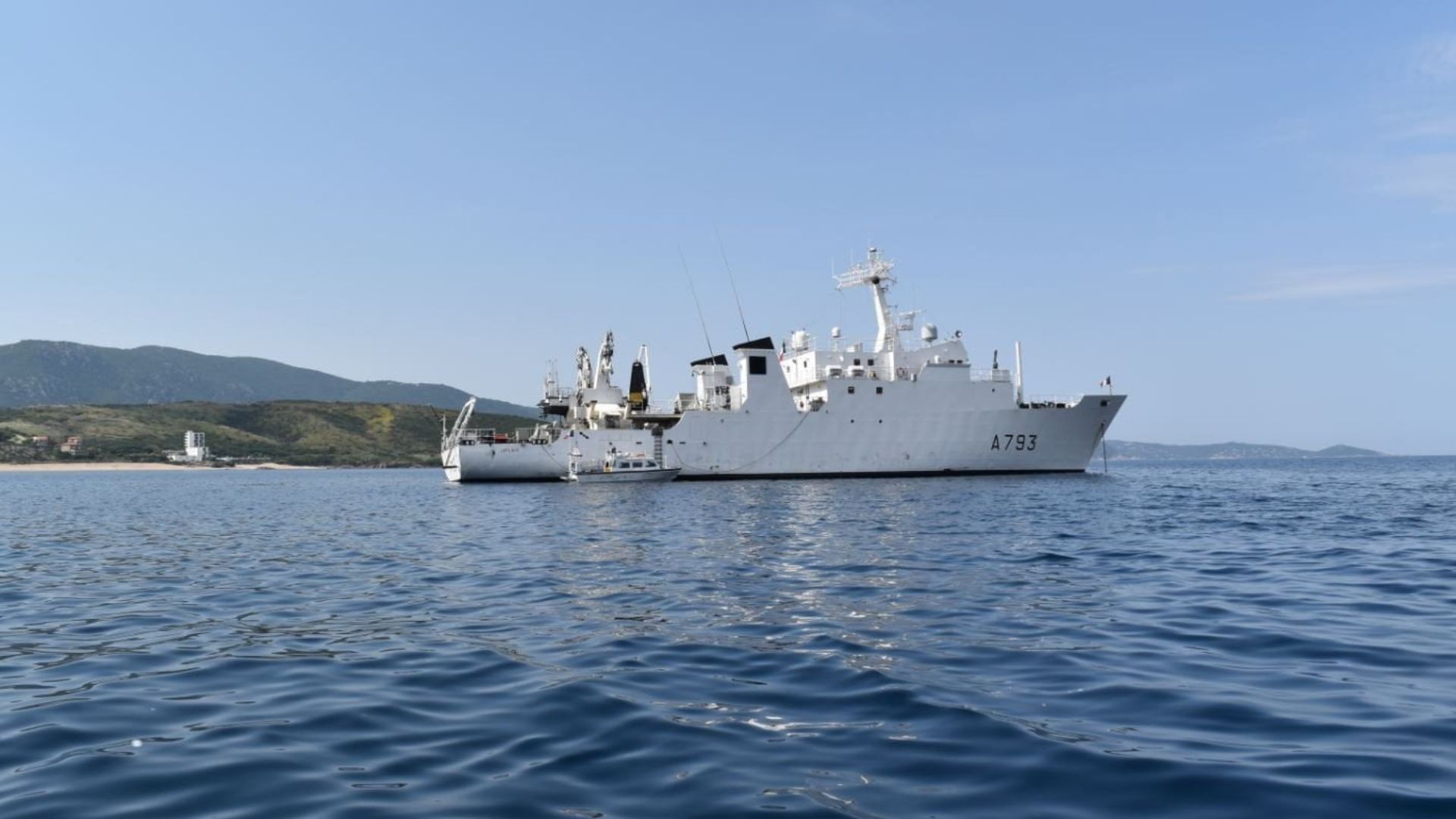
Speedboats and survey vessels equipped with SBG Navsight Inertial Navigation Systems for bathymetry.
“The Apogee is highly versatile; it fits both deep and shallow water requirements.” | Rémi Labonde, in charge of Positioning and Hydrographic Equipment at Shom
Shom, the French national hydrographic and oceanographic office
Shom, as a public institution, has 3 major objectives: national hydrography and cartography, defense support in hydro-oceanographic fields, and support in maritime geospatial products and services for public policies on the sea and the coast.
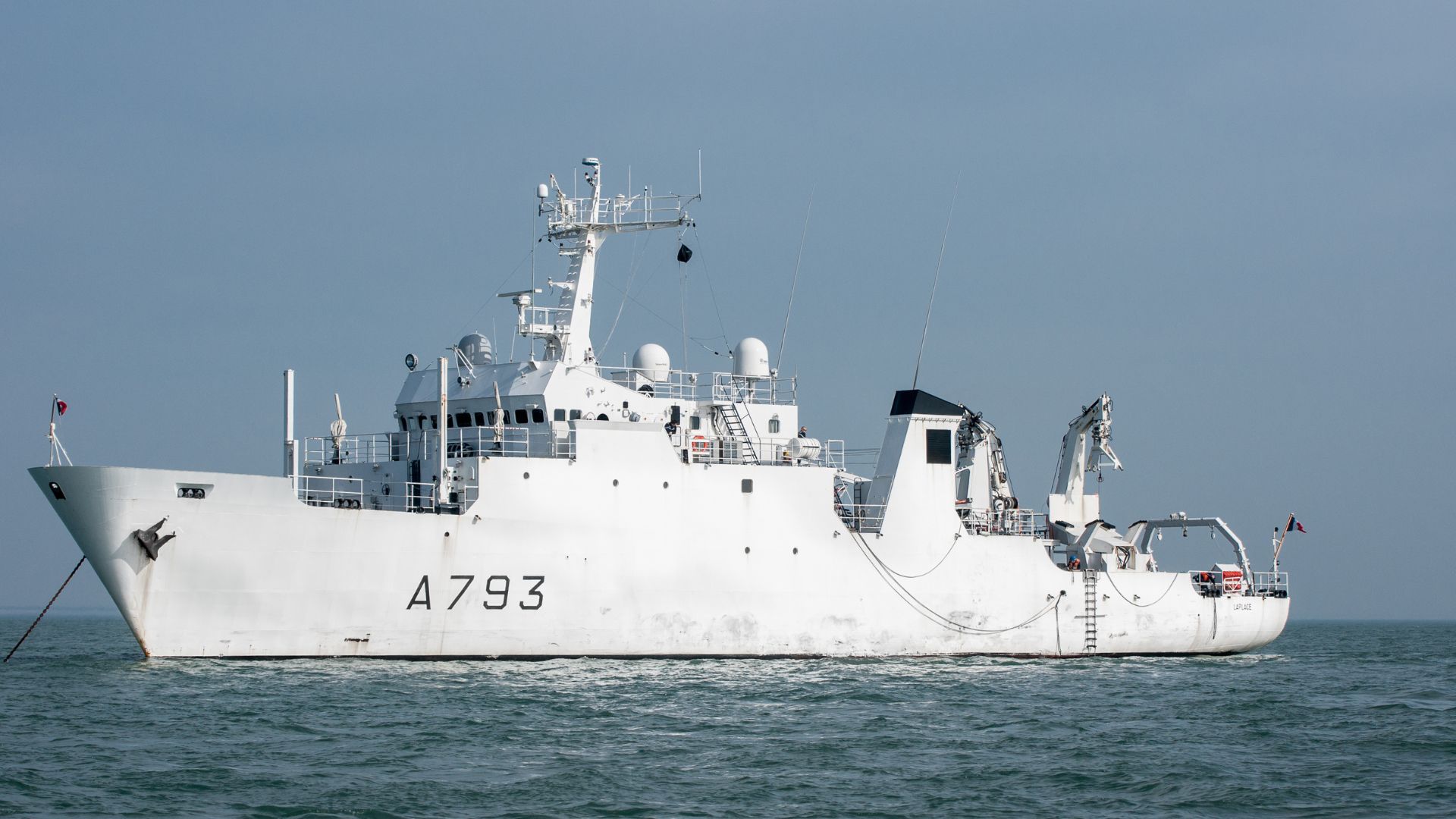
The fleet used by Shom is based in Brest and is composed of eleven boats, including seven speedboats, and three 59-meter long BH2 survey vessels. They operate on shallow and deep water in France, Africa, the Indian Ocean and in the Caribbean Sea.
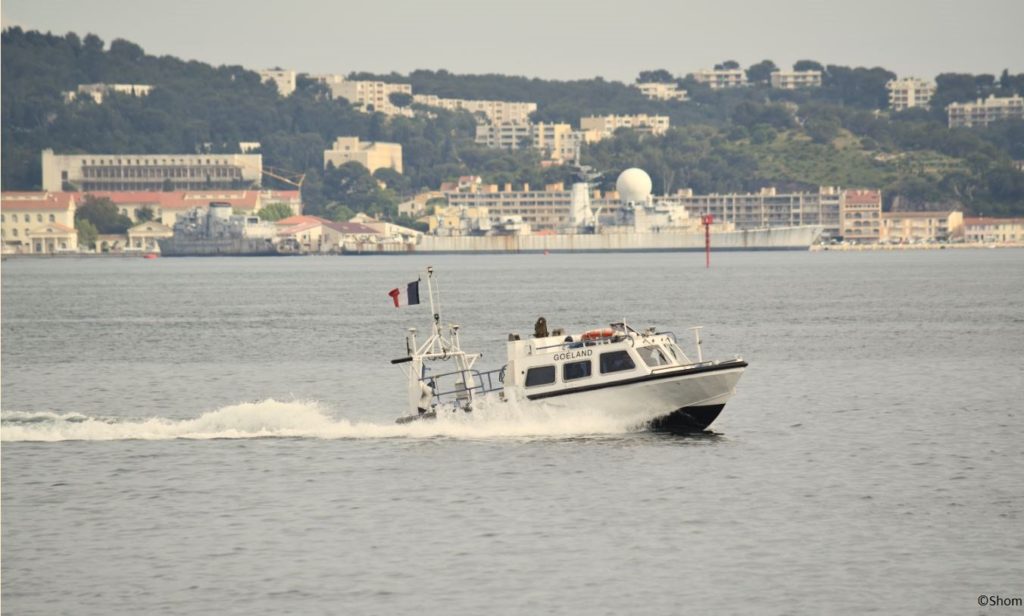
Shom also uses a fleet based in New Caledonia composed of two boats, one speedboat and a buoy-laying Vessel used part of the time for hydrographic surveys.
Renewing the fleet of Inertial Navigation Systems with SBG
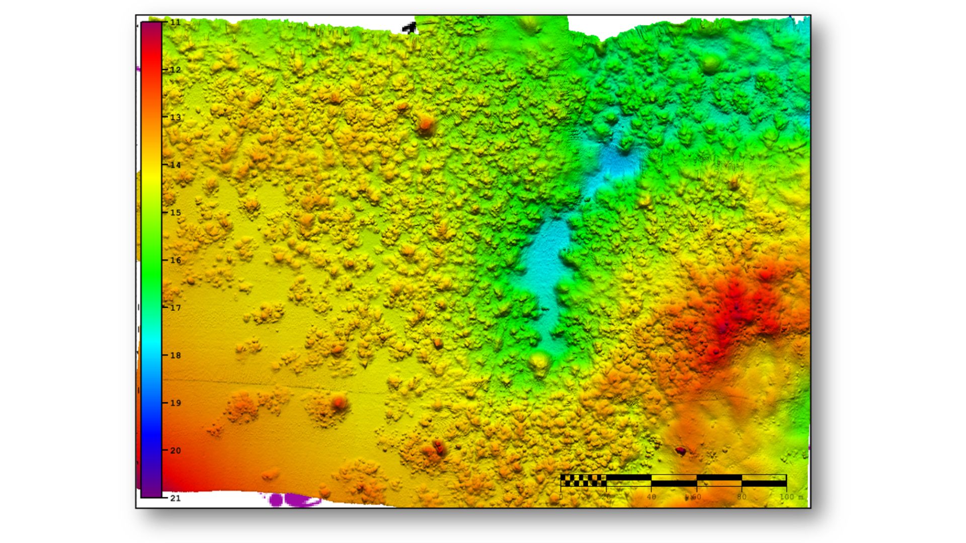
When it came to renewing the fleet of inertial navigation systems (INS), the Shom looked at INS complying with IHO standards for bathymetric surveys, with a focus on roll and heave that have the biggest impact on the multibeam echo sounder data compensation.
After having conducted several tests in their official test zone where each element’s location is strictly and precisely known, Shom selected SBG Systems for the replacement of inertial navigation systems. If at first, they acquired a Navsight Ekinox grade (0.02° roll) for shallow water survey in New Caledonia, they then decided to move the fleet in Brest with Apogee grade INS solutions (0.008° roll).
“The Apogee is highly versatile; it fits both deep and shallow water requirements. Having a homogenized fleet of sensors for speedboats and BH2 is easier to maintain, like the number of spare equipment, for example” explains Rémi Labonde, in charge of Positioning and Hydrographic Equipment at Shom.
Navsight Apogee features
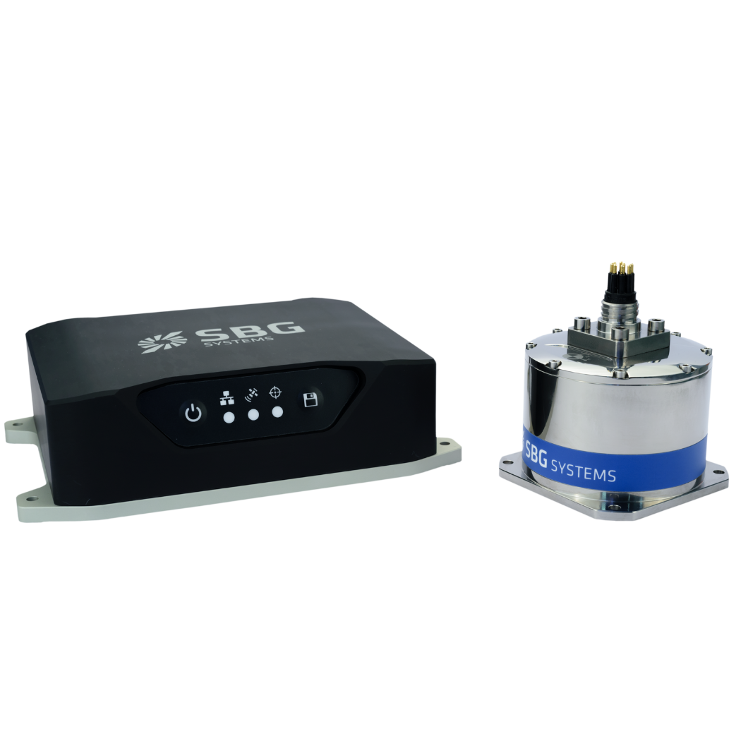
Designed for hydrographers, Navsight Apogee grade is composed of a GNSS receiver and a processing unit enabling the real-time fusion of inertial and navigation data.
Navsight provides connections to several external equipment such as echo sounders, computers, etc. The Apogee sensor’s titanium enclosure allows installation in the floodable engine compartment, near the multibeam echo sounder.
Navsight Apogee solution is a high performance cost-effective inertial navigation system based on state-of-the-art MEMS technology; it, therefore, requires no annual maintenance.
Our solution includes free unlimited firmware updates and technical support. “We have selected SBG for the good performance/price ratio and the high level of service. The SBG technical support team is available, reactive, and committed,” adds the Shom professional.
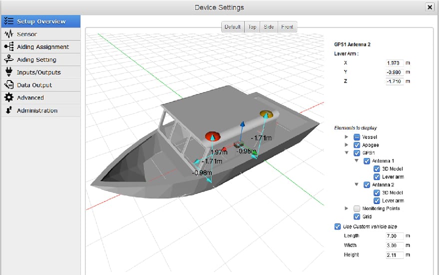
Another key factor when choosing the INS solution was the ease of use. Once connected through Ethernet, the Navsight inner web interface guides the user during the installation phase.
For example, the system shows a 3D view of the boat, letting users check the installation in real-time.
The embedded filter also controls and validates lever arms and antenna alignment during this procedure, which can be a plus if the Shom needs to calibrate a new system abroad.
“We are big fans of SBG’s web interface. It is modern, extremely clear, and easy to use; it really makes a difference in our team’s work” to conclude Rémi Labonde.
Navsight Marine
Navsight Marine integrates the latest IMU and GNSS technologies to offer a complete, powerful, and user friendly motion and navigation solution for Hydrographers.
Easy to set up, and highly versatile, Navsight Marine makes hydrographers’ surveying tasks easier on both shallow and deep waters.
The IMU is the main sensing element and the most important performance driving factor.
Ask a quotation for Navsight Marine
Do you have questions?
Welcome to our FAQ section! Here, you’ll find answers to the most frequent questions about the applications we highlight. If you don’t find what you’re looking for, feel free to contact us directly!
What are wave measurement sensors?
Wave measurement sensors are essential tools for understanding ocean dynamics and improving safety and efficiency in marine operations. By providing accurate and timely data on wave conditions, they help inform decisions across various sectors, from shipping and navigation to environmental conservation. Wave buoys are floating devices equipped with sensors to measure wave parameters such as height, period, and direction.
They typically use accelerometers or gyroscopes to detect wave motion (e.g. wave period) and can transmit real-time data to shore-based facilities for analysis.
What is bathymetry?
Bathymetry is the study and measurement of the depth and shape of underwater terrain, primarily focused on mapping the seafloor and other submerged landscapes. It is the underwater equivalent of topography, providing detailed insights into the underwater features of oceans, seas, lakes, and rivers. Bathymetry plays a crucial role in various applications, including navigation, marine construction, resource exploration, and environmental studies.
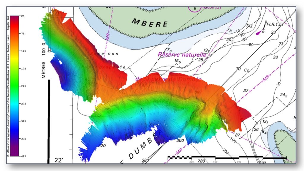
Modern bathymetric techniques rely on sonar systems, such as single-beam and multibeam echo sounders, which use sound waves to measure water depth. These devices send sound pulses toward the seafloor and record the time it takes for the echoes to return, calculating depth based on the speed of sound in water. Multibeam echo sounders, in particular, allow for wide swaths of the seafloor to be mapped at once, providing highly detailed and accurate seafloor representations. Frequently, a RTK + INS solution is associated to create accurately positioned 3D bathymetric representations of the seafloor.
Bathymetric data is essential for creating nautical charts, which help guide vessels safely by identifying potential underwater hazards like submerged rocks, wrecks, and sandbanks. It also plays a vital role in scientific research, helping researchers understand underwater geological features, ocean currents, and marine ecosystems.
What is a buoy used for?
A buoy is a floating device primarily used in maritime and water-based environments for several key purposes. Buoys are often placed in specific locations to mark safe passages, channels, or hazardous areas in bodies of water. They guide ships and vessels, helping them avoid dangerous spots like rocks, shallow waters, or wrecks.
They are used as anchoring points for vessels. Mooring buoys allow boats to tie up without having to drop anchor, which can be especially useful in areas where anchoring is impractical or damaging to the environment.
Instrumented buoys are equipped with sensors to measure environmental conditions like temperature, wave height, wind speed, and atmospheric pressure. These buoys provide valuable data for weather forecasting, climate research, and oceanographic studies.
Some buoys act as platforms for collecting and transmitting real-time data from the water or seabed, often used in scientific research, environmental monitoring, and military applications.
In commercial fishing, buoys mark the location of traps or nets. They also help in aquaculture, marking the locations of underwater farms.
Buoys can also mark designated areas such as no-anchoring zones, no-fishing zones, or swimming areas, helping enforce regulations on the water.
In all cases, buoys are critical for ensuring safety, facilitating marine activities, and supporting scientific research.
What is buoyancy?
Buoyancy is the force exerted by a fluid (such as water or air) that opposes the weight of an object submerged in it. It allows objects to float or rise to the surface if their density is less than that of the fluid. Buoyancy occurs because of the difference in pressure exerted on the object’s submerged portions—greater pressure is applied at lower depths, creating an upward force.
The principle of buoyancy is described by Archimedes’ principle, which states that the upward buoyant force on an object is equal to the weight of the fluid displaced by the object. If the buoyant force is greater than the object’s weight, it will float; if it is less, the object will sink. Buoyancy is essential in many fields, from marine engineering (designing ships and submarines) to the functionality of floating devices like buoys.
Whats an IMU ?
An Inertial Measurement Unit (IMU) is a compact sensor module that measures the motion and orientation of a platform by capturing its linear accelerations and angular rotation rates. At its core, an IMU integrates three accelerometers and three gyroscopes arranged along orthogonal axes to provide six degrees of measurement.
Accelerometers sense how the platform accelerates in space, while gyroscopes track how it rotates. By processing these measurements together, an IMU delivers precise information about changes in velocity, attitude, and heading without relying on any external signals. This makes IMUs essential for navigation in environments where GPS is unavailable, unreliable, or intentionally denied. Their performance depends heavily on sensor quality, calibration, and how well errors—such as biases, noise, scale factors, and misalignments—are controlled.
High-grade IMUs include advanced calibration, thermal compensation, vibration filtering, and bias stability mechanisms to ensure that errors do not accumulate rapidly over time. Because of these characteristics, IMUs are used across a wide range of applications—from UAVs, loitering munitions, and autonomous vehicles to AUVs, robotics, and industrial stabilization systems—providing robust, continuous awareness of motion and orientation even in the harshest operational conditions.
