
Dynamic Positioning
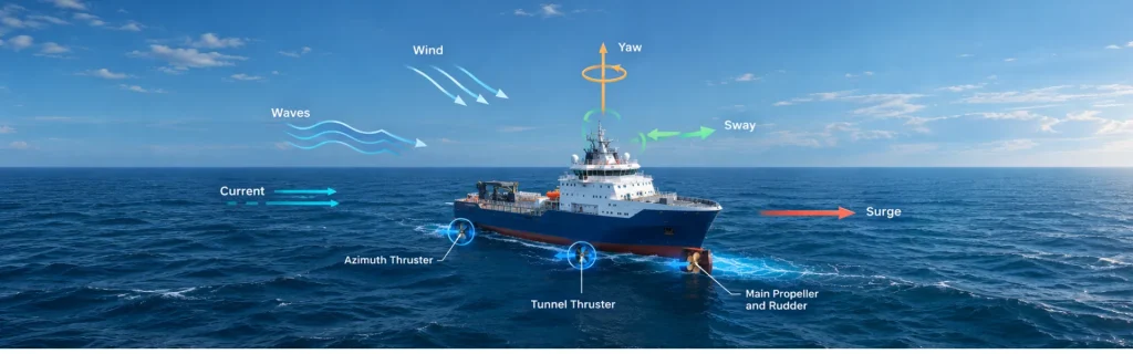
Dynamic Positioning (DP) is a computer-controlled marine control system that automatically maintains a vessel’s position and heading using active propulsion and thrusters. Unlike conventional mooring, DP does not rely on anchors to keep the vessel on station. Instead, it uses a closed-loop control architecture that combines position reference systems, heading sensors, motion sensors, environmental measurements, control algorithms and propulsion.
A DP system continuously compares the vessel’s measured state with its commanded position and heading. The DP controller then calculates the forces required to reduce any deviation. Thruster allocation algorithms convert these required forces into commands for individual thrusters and propulsion units. As a result, the vessel can maintain its position and heading despite wind, waves, currents, and other external forces.
Sensors are vital to this process. Position Reference Systems (PRS) can use GNSS, acoustic positioning, laser systems, radar, or taut wire technologies. Gyrocompasses and inertial sensors provide accurate heading and rate-of-turn measurements. Meanwhile, MRUs measure roll, pitch, heave, acceleration, and angular rates. Wind sensors also provide essential environmental data for estimating external forces.
Furthermore, DP controllers can use mathematical vessel models and Kalman filtering to estimate position, velocity, heading, and environmental disturbances. These estimates help the system distinguish actual vessel motion from sensor noise and unmodelled forces. Therefore, accurate and reliable sensor data directly influences DP performance and operational resilience.
Inertial navigation systems can further strengthen DP architectures. An INS combines inertial measurements with GNSS and other external references to provide continuous navigation data.
During a GNSS outage, INS estimates position, heading, and motion while its position error gradually increases without external corrections.
Dynamic Positioning continuously measures, estimates, compares, calculates, and adjusts thrust to maintain precise vessel position and heading during demanding offshore operations.