UAV motion compensation and point cloud georeferencing
BOE uses Ellipse-D for UAV motion compensation and point cloud georeferencing.
“We heard some good reviews about SBG sensors being used in the surveying industry, so we conducted some tests with the Ellipse2-D and the results were exactly what we needed.” | Jason L., founder of BoE Systems
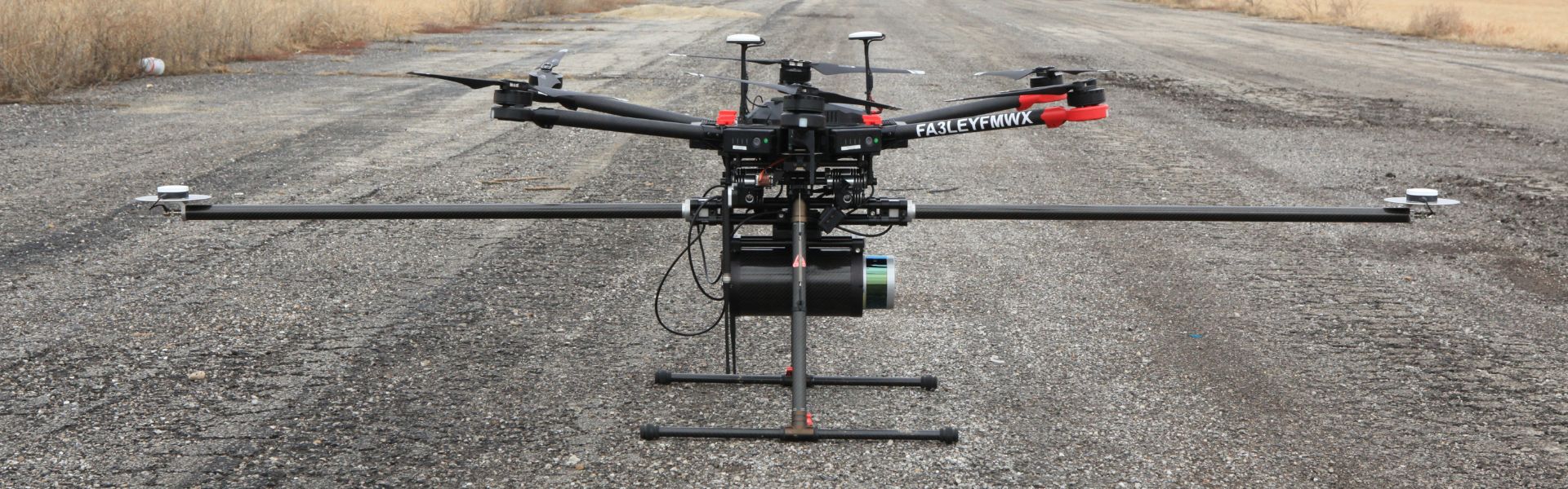
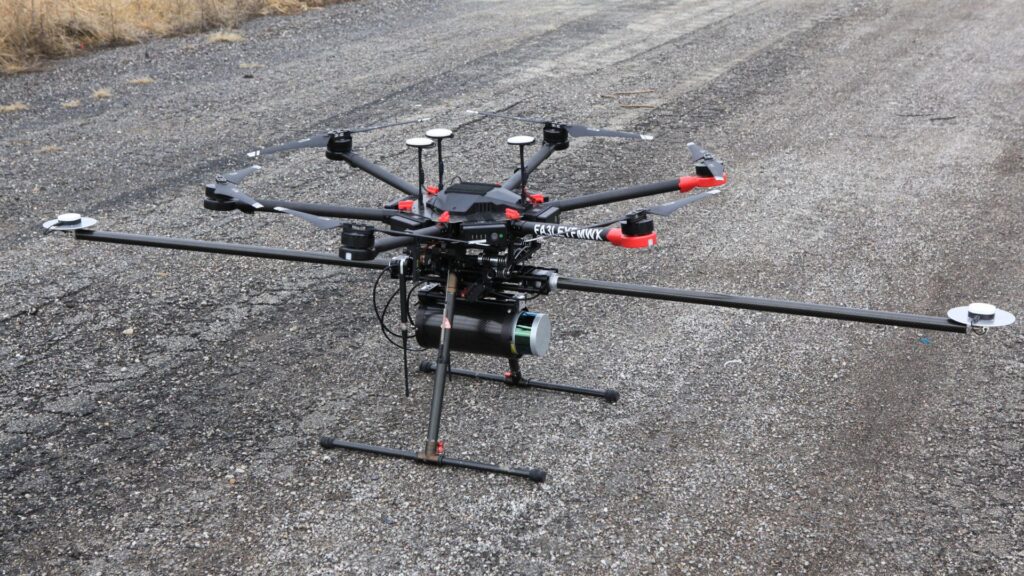
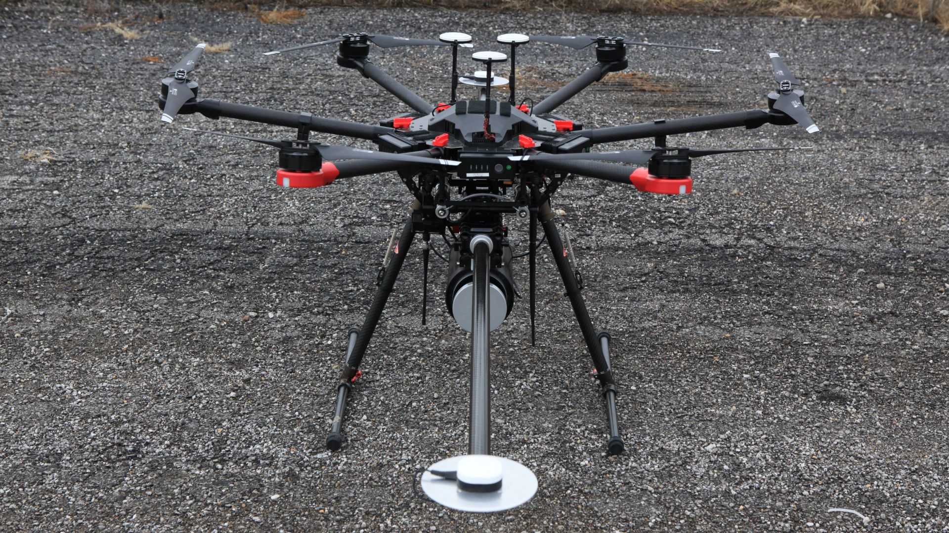
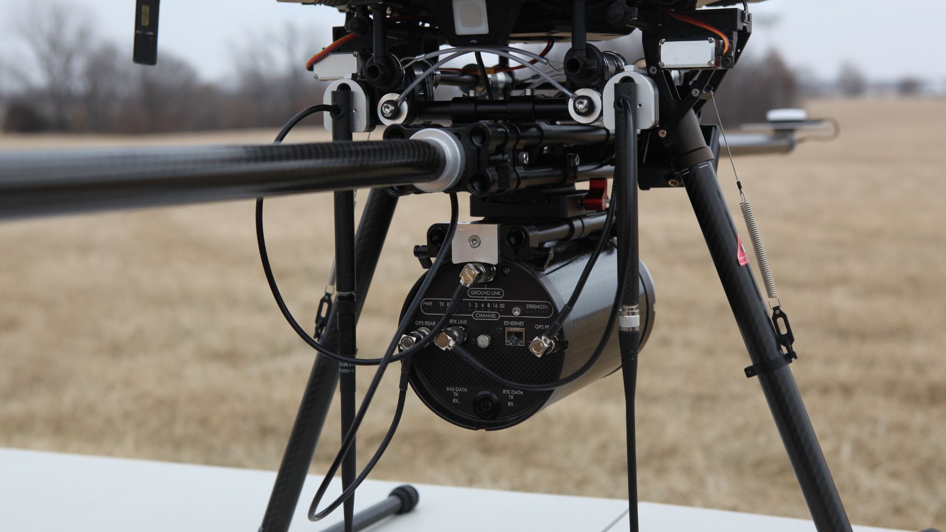
BoE Systems entered the mobile mapping industry with the ELV16 Scanner, the most compact aerial-based LiDAR solution of the market.
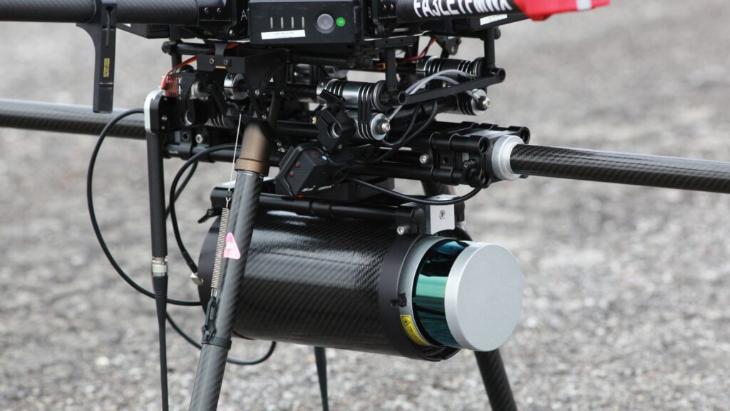
The ELV16 Scanner is equipped with a Velodyne LiDAR sensor and an SBG Systems Ellipse-D inertial navigation sensor. The ELV16 Scanner is a versatile, economic, and smart solution for LiDAR data acquisition.
Versatile solution for LiDAR data acquisition
The ELV16 Scanner includes a complete drone-based aerial LiDAR data collection and control system.
BOE scanner’s success centers around a superbly integrated Velodyne LiDAR sensor, Ellipse-D inertial navigation system, GNSS antennas, an onboard computer, communication equipment, and a dedicated power supply.
The scanner mounts securely on a DJI Matrice 600 Pro UAV for simple, safe, and effective site access. Moreover, operators control the ELV16 Scanner remotely through a simple, user-friendly interface.
Featuring a robust suite of continuous monitoring capabilities, the operator can control and monitor the streaming data acquisition from start to finish with a few taps on a smart device or clicks on a laptop.
“You can start your data acquisition at takeoff, or you can start the data collection when the UAV is right on top of the specific zone to survey, and then stop it whenever you want” declares Jason L., founder of BoE Systems.
This approach allows users the flexibility to collect only the data they require; meaning less time on post-processing. And when it’s time for post-processing, the ELV16 Scanner outputs the industry-standard LAS data files, which import seamlessly into all major drafting and modeling software.
UAV motion compensation & georeferencing
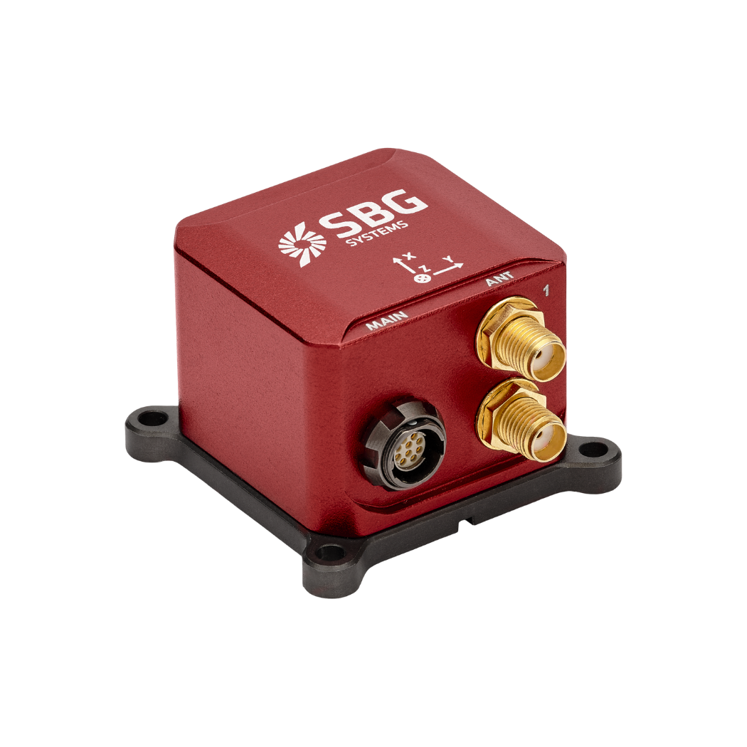
Ellipse-D is a Dual Antenna Inertial Navigation System with an embedded RTK GNSS receiver and post-processing capabilities. Moreover, the mobile mapping industry values it for its smart balance of accuracy, weight, and price.
Our INS provides roll, pitch, GNSS-based heading, and centimeter-level positioning. In addition, it compensates for UAV motion to orient and geo-reference the LiDAR-generated point cloud.
Ellipse-D is factory calibrated in dynamics and temperature which ensures a constant behavior whatever the conditions. GNSS-based heading makes it immune to magnetic fi eld, so the UAV can get close to power lines without disturbance.
To get the best performance, specific motion profiles have been designed, taking into account UAV specific vehicle motion characteristics. “We heard some good reviews about SBG sensors being used in the surveying industry, so we conducted some tests with the Ellipse-D and the results were exactly what we needed” concludes Jason.
“The Ellipse-D is widely used in the mobile mapping industry because of its smart balance of accuracy, weight and price”. | Jason L., founder of BoE Systems.
About the BoE ELV16
BoE Systems integrates cutting-edge hardware and software to provide highly accurate geospatial data collection solutions.
Our drone-based aerial LiDAR systems creates detail-rich 3-dimensional models for a variety of industries such as transportation, utilities, mining, construction, and more.
Analytics are applied to determine critical data points such as geodetic locations, slope identification, point-to-point measurements, volumetrics, and more.
Our models are perfect for creating digital elevation models, overlaying contour lines, and even supporting predictive analytics such as flooding and drainage analysis. Finally with our solutions you get enhanced dead-reckoning accuracy.
Ellipse-D
Ellipse-D is an inertial navigation system integrating a dual antenna and dual frequency RTK GNSS that is compatible with our Post-Processing software Qinertia.
Designed for robotic and geospatial applications, it can fuse Odometer input with Pulse or CAN OBDII for enhanced dead-reckoning accuracy.
Ask a quotation for Ellipse-D
Do you have questions?
Welcome to our FAQ section! Here, you’ll find answers to the most common questions about the applications we showcase. If you don’t find what you’re looking for, feel free to contact us directly!
Do UAVs use GPS?
Unmanned Aerial Vehicles (UAVs), commonly known as drones, typically use Global Positioning System (GPS) technology for navigation and positioning.
GPS is an essential component of a UAV’s navigation system, providing real-time location data that enables the drone to determine its position accurately and execute various tasks.
In recently years, this term has been replaced by a new term GNSS (Global Navigation Satellite System). GNSS refers to the general category of satellite navigation systems, which encompasses GPS and various other systems. In contrast, GPS is a specific type of GNSS developed by the United States.
How do we ensure sensor quality standards for UAV military applications?
At SBG Systems, ensuring the highest quality standards for our inertial measurement units (IMUs) involves a meticulous process. We begin with the optimal selection of high-end MEMS components, focusing on reliable accelerometers and gyroscopes that meet our stringent quality requirements. Our IMUs are housed in robust casings designed to withstand vibrations and environmental conditions, guaranteeing durability and performance.
Our automated calibration process involves a 2-axis table and addresses temperature ranges from -40°C to 85°C. This calibration compensates for various factors including biases, cross-axis effects, misalignment, scale factors, and non-linearities in accelerometers and gyroscopes, ensuring consistent performance in all weather conditions.
Our qualification process further involves strict in-house screening to ensure that only sensors meeting our specifications continue through production. Each IMU is accompanied by a detailed calibration report and is guaranteed for two years. This rigorous approach ensures high quality, reliability, and consistent performance over time, delivering superior IMUs for defense and other critical applications.
We also conducts thorough environmental and endurance testing to ensure reliability. Some of our sensors meet several MIL-STD standards, guaranteeing resistance to shock, vibration, and extreme conditions.
What is UAV geofencing?
UAV geofencing is a virtual barrier that defines specific geographic boundaries within which an unmanned aerial vehicle (UAV) can operate.
This technology plays a critical role in enhancing the safety, security, and compliance of drone operations, particularly in areas where flight activities may pose risks to people, property, or restricted airspace.
In industries like delivery services, construction, and agriculture, geofencing helps ensure that drones operate within safe and legal areas, avoiding potential conflicts and enhancing operational efficiency.
Law enforcement and emergency services can use geofencing to manage UAV operations during public events or emergencies, ensuring drones do not enter sensitive areas.
Geofencing can be employed to protect wildlife and natural resources by restricting drone access to certain habitats or conservation areas.
What is a payload?
A payload refers to any equipment, device, or material that a vehicle (drone, vessel …) carries to perform its intended purpose beyond the basic functions. The payload is separate from the components required for the vehicle operation, such as its motors, battery, and frame.
Examples of Payloads:
- Cameras: high-resolution cameras, thermal imaging cameras…
- Sensors: LiDAR, hyperspectral sensors, chemical sensors…
- Communication equipment: radios, signal repeaters…
- Scientific instruments: weather sensors, air samplers…
- Other specialized equipment
