Ellipse helps fight wildfires
Fire Flight’s solution employs our Inertial Measurement Unit (IMU) to help fight wildfires.
“The Ellipse was a simple GPS/IMU to integrate into our system, backed up by good technical support. As a result we have been able to successfully deploy our fire mapping systems worldwide. I am thankful for the support that my team and I have received over the past few years.” | Dr Paul D., Chief Executive Officer, Fire Flight Technologies
Climate change has contributed to the increased risk and extent of wildfires (known as bush fires in Australia).
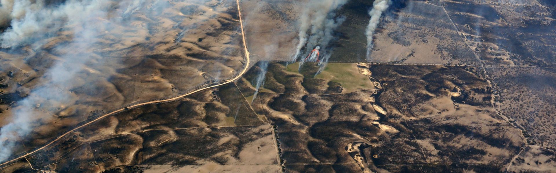
Wildfires destroy thousands of hectares of forests each year. Prediction and early detection of wildfires can save lives, infrastructure, and ecologically sensitive areas.
Equally important is planning for recovery during and aftermath of a forest fire. As wildfires are becoming more frequent, fire agencies rely on technologies generating real-time fire maps to fight wildfires.
Fire Flight, based in Australia, is a global provider of real-time fire mapping and fire intelligence services. The company provides its end user (like fire managers and fire agencies) with information on fire boundaries as well as thermal image maps of the fire.
Fire Flight fire mapping system is a combination of hardware (fire mapping cameras, GPS/IMU, computers) and software mounted on a manned aircraft. The aircraft is flown high above active forest fires, where it creates accurate maps in real-time.
These maps are shared with the end user to help them devise plans for fighting the fires.
IMU accuracy is the key
The fire map’s geospatial accuracy directly depends on the IMU accuracy integrated into the system. Moreover, Fire Flight aimed to use a cost-effective IMU that delivers accurate real-time data to the fire-mapping system.
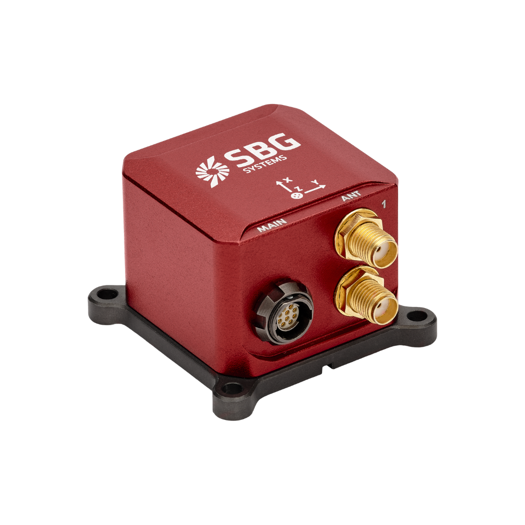
In the past, they purchased IMUs elsewhere; however, those units delivered low accuracy and caused dissatisfaction. After testing several competitors, Fire Flight ultimately approved our Ellipse-D solution. Furthermore, after analyzing their needs, our product team recommended Ellipse-D as the best option.
Ellipse-D, a dual-antenna INS, provides more accurate heading than single-antenna systems. However, Fire Flight raised concerns about installing Ellipse-D’s dual GNSS antennas. They worried about potential installation challenges and additional certification requirements.
A seamless integration
After initial tests and demonstrations, the Fire Flight team was fully convinced to employ Ellipse-D’s dual GNSS as recommended by us. They chose Ellipse-D for its reliability and high accuracy. Fire Flight commended our Support Team for their prompt response during the integration phase.
Integration of Ellipse-D into Fire Flight’s fire mapping system was seamless! This partnership exemplifies how innovative technologies can address critical challenges posed by climate change.
We are extremely proud to be part of Fire Flight’s solution of airborne imaging technology to help them in their mission of protecting people, property, and the environment.


Ellipse-D
Ellipse-D is an inertial navigation system integrating a dual antenna and dual frequency RTK GNSS that is compatible with our Post-Processing software Qinertia.
Designed for robotic and geospatial applications, it can fuse Odometer input with Pulse or CAN OBDII for enhanced dead-reckoning accuracy.
Ask a quotation for Ellipse-D
Do you have questions?
Welcome to our FAQ section! Here, you will find answers to the most common questions about our showcased applications. Moreover, if you do not find the information you seek, please contact us directly for further assistance.
What is the difference between IMU and INS?
The difference between an Inertial Measurement Unit (IMU) and an Inertial Navigation System (INS) lies in their functionality and complexity.
An IMU (inertial measuring unit) provides raw data on the vehicle’s linear acceleration and angular velocity, measured by accelerometers and gyroscopes. It supplies information on roll, pitch, yaw, and motion, but does not compute position or navigation data. The IMU is specifically designed to relay essential data about movement and orientation for external processing to determine position or velocity.
On the other hand, an INS (inertial navigation system) combines IMU data with advanced algorithms to calculate a vehicle’s position, velocity, and orientation over time. It incorporates navigation algorithms like Kalman filtering for sensor fusion and integration. An INS supplies real-time navigation data, including position, velocity, and orientation, without relying on external positioning systems like GNSS.
This navigation system is typically utilized in applications that require comprehensive navigation solutions, particularly in GNSS-denied environments, such as military UAVs, ships, and submarines.
What is the difference between RTK and PPK?
Real-Time Kinematic (RTK) is a positioning technique where GNSS corrections are transmitted in near real time, typically using an RTCM format correction stream. However, there can be challenges in ensuring the GNSS corrections, specifically their completeness, availability, coverage, and compatibility.
The major advantage of PPK over RTK post processing is that the data processing activities can be optimized during post-processing, including forward and backward processing, whereas in real-time processing, any interruption or incompatibility in the corrections and their transmission will lead to lower accuracy positioning.
A first key advantage of GNSS post-processing (PPK) vs. real time (RTK) is that the system used on the field does not need to have a datalink/radio to feed the RTCM corrections coming from the CORS into the INS/GNSS system.
The main limitation to post processing adoption is the requirement of the final application to act on the environment. On the other hand, if your application can withstand the additional processing time needed to produce an optimized trajectory, it will greatly improve the data quality for all your deliverables.
What is GNSS vs GPS?
GNSS stands for Global Navigation Satellite System and GPS for Global Positioning System. These terms are often used interchangeably, but they refer to different concepts within satellite-based navigation systems.
GNSS is a collective term for all satellite navigation systems, while GPS refers specifically to the U.S. system. It includes multiple systems that provide more comprehensive global coverage, while GPS is just one of those systems.
You get improved accuracy and reliability with GNSS, by integrating data from multiple systems, whereas GPS alone might have limitations depending on satellite availability and environmental conditions.
