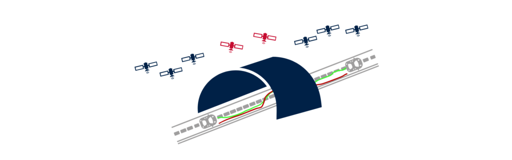
Forwards-backwards paths overlaid happens when a post-processing software overlays two inertial paths to improve accuracy during GNSS outages. The software first calculates the forward path. It processes data in the order it was recorded. Drift accumulates during GNSS-denied segments. Then, it processes the same data in reverse. It starts from the point where GNSS signal is reacquired. Drift accumulates in the opposite direction.
Overlaying both paths allows the PPK software to compare results. It identifies consistent motion and rejects conflicting drift. This process enhances accuracy in GNSS-degraded environments. It also improves trajectory reconstruction during signal loss. The forward path captures dynamics immediately after signal loss. The backward path captures them leading into signal reacquisition.
When overlaid, these paths highlight common motion features. The post-processing software extracts the most accurate sections from both paths. It merges them into one optimal trajectory. This combined solution reduces accumulated drift. It also strengthens position, velocity, and attitude estimates.
Overlaying helps correct inertial-only drift patterns. It improves lateral and vertical positioning. It also enhances heading accuracy during long GNSS outages. The process operates entirely in post-processing. It uses recorded data without requiring real-time correction.
This technique applies well in tunnels, forests, and urban canyons. It also helps in underwater and underground surveys. Forwards-backwards overlays enable better dead-reckoning. They complement tight GNSS/INS integration.
The method supports 3D correction. It refines roll, pitch, and yaw estimates. It maintains high data quality despite poor GNSS. The approach works best with low-noise IMU data. High-resolution inertial sensors improve results.
The forwards-backwards paths overlaid offer a practical solution. They enhance GNSS-aided INS data in complex environments. They increase confidence in post-processed trajectories. The technique helps users reconstruct accurate motion in challenging zones. It is a key tool in advanced inertial navigation.
Qinertia GNSS+INS PPK software
Qinertia PPK software offers an all-new level in high-precision positioning solutions. Achieve unparalleled accuracy in your workflows by post-processing your raw location data.
Discover all features