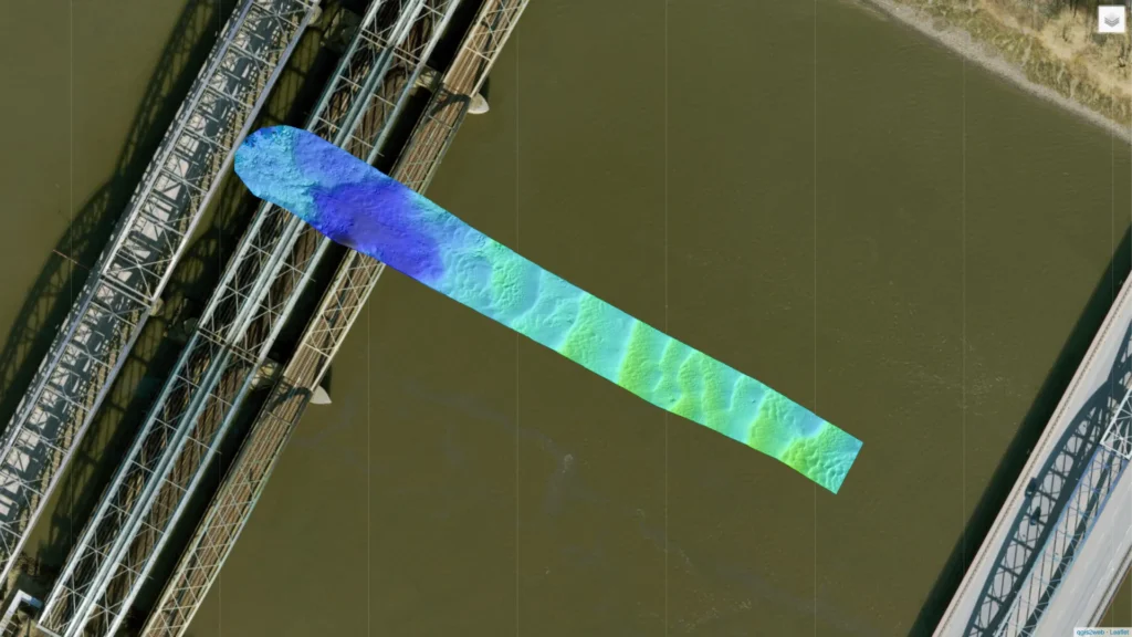
SBG Systems presents the Underbridge 180° Turn survey map, showcasing a challenging navigation test along Hamburg’s Elbbrücken. This survey visualizes the river surface of the Elbe, highlighting bathymetric quality layers, trajectories, and performance under extreme GNSS conditions.
Surveyors equipped the vessel with a tightly coupled Inertial Navigation System and performed a complete 180° turn directly beneath the Elbbrücken. During this maneuver, the GNSS signal was intentionally lost, creating a real-world simulation of total RTK outage. Despite the GNSS interruption, the INS continued to deliver reliable data throughout the turn. The navigation system maintained stability, enabling precise bathymetric mapping and motion compensation without real-time corrections.
Engineers post-processed the data using a high-end fiber-optic inertial sensor solution. This solution served as the reference for evaluating bathymetric difference surfaces and navigation accuracy.
Which data is included in the survey map?
The resulting interactive webmap includes computed bathymetric layers, survey lines, and quality indicators across the full 180° turn path. The data demonstrates the INS’s ability to handle abrupt direction changes and signal loss in confined spaces.
Surveyors designed this test to simulate GNSS-denied conditions, common in urban waterways, ports, and under bridges. The mission assessed how inertial solutions alone maintain accuracy during full outages. The tightly coupled INS performed with exceptional consistency and minimal drift during the GNSS blackout. This performance validated its value for autonomous systems and hydrography in signal-obstructed environments.
The 3D webmap allows users to interact with and analyze the Underbridge 180° Turn survey area in high detail. Bathymetric surfaces show seamless coverage across the maneuver, supported entirely by inertial navigation.
We invite marine surveyors, hydrographers, and researchers to explore this webmap. Analyze the trajectory data, outage conditions, and sensor performance during the Elbbrücken underbridge test. This test underscores the importance of robust post-processing and inertial navigation when real-time corrections are unavailable. It confirms the Horizon INS and fiber-optic systems as reliable tools for high-precision missions under the most demanding conditions.
How to use the survey map visualization:
1 – One continuous click with 1 finger for a 360º move.
2 – Use trackpad 2 fingers gesture for zoom in/out
3 – Select all features you want to be presented (e.g. colors, survey line, etc.)
Get full access to other SBG Systems’ products test reports.