Backward processing is a GNSS post-processing technique that computes position and trajectory from the end of a dataset to the beginning. It follows the same principles as forward processing but in reverse chronological order. This method uses raw GNSS data and reference station corrections to estimate position, velocity, and orientation.
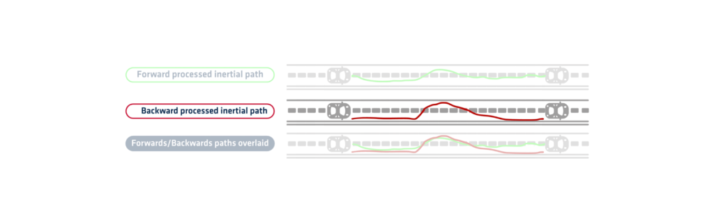
The algorithm starts at the final epoch and moves backward through the collected data (backwards processed inertial path). It applies satellite orbit models, clock corrections, and atmospheric models. Each calculated position uses data from later time steps to refine earlier ones. This direction can help improve accuracy in sections with temporary signal loss or degradation.
Backward processing is especially effective when combined with forward processing. Merging both solutions creates a more robust trajectory with fewer errors. This merged approach uses the strengths of both directions to compensate for weaknesses in each. For example, if forward processing struggles at the end of a dataset, backward processing can correct it.
When paired with an Inertial Navigation System (INS), it further enhances positioning. The system uses Kalman filtering to blend GNSS and inertial data. This combination delivers high accuracy, even in GNSS-challenged environments. It is particularly useful for UAVs, mobile mapping, and marine surveys.
Backward processing also allows users to validate forward results. By comparing the two, users can detect inconsistencies and improve data reliability. Some software solutions automatically switch between forward and backward modes based on data quality.
This method requires access to the complete dataset, so it is only used in post-mission analysis. It cannot provide real-time corrections. Despite this, it remains a valuable tool in high-precision applications.
In conclusion, it strengthens GNSS-based positioning by improving accuracy, filling data gaps, and refining trajectory estimates from the end to the beginning.
Qinertia GNSS+INS PPK software
Qinertia PPK software offers an all-new level in high-precision positioning solutions. Achieve unparalleled accuracy in your workflows by post-processing your raw location data.
Discover all features