Marine Technology integrates SBG’ INS/GNSS in their USV HydroDron
Our client, Marine Technology presented their fully new hydrographic unmanned vessel at BaltExpo equipped with our Ekinox-D INS.
“Ekinox-D is the perfect RTK INS/GNSS for USV as it combines survey grade GNSS in a very compact form factor.” | Marine Technology
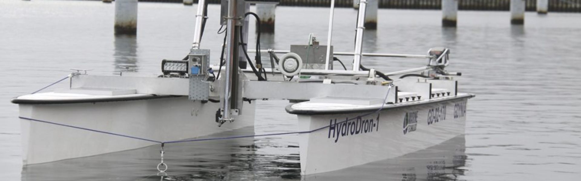
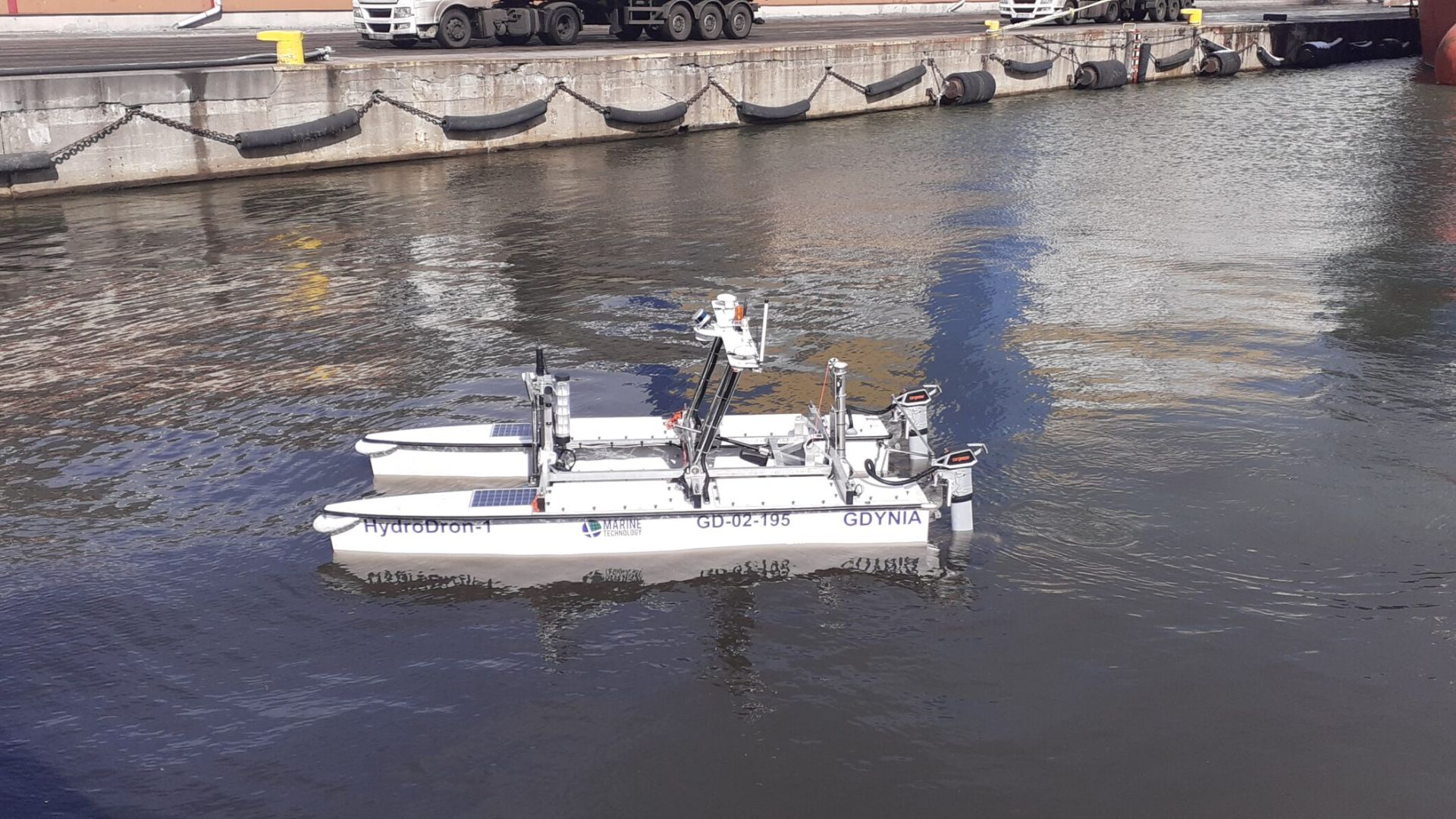
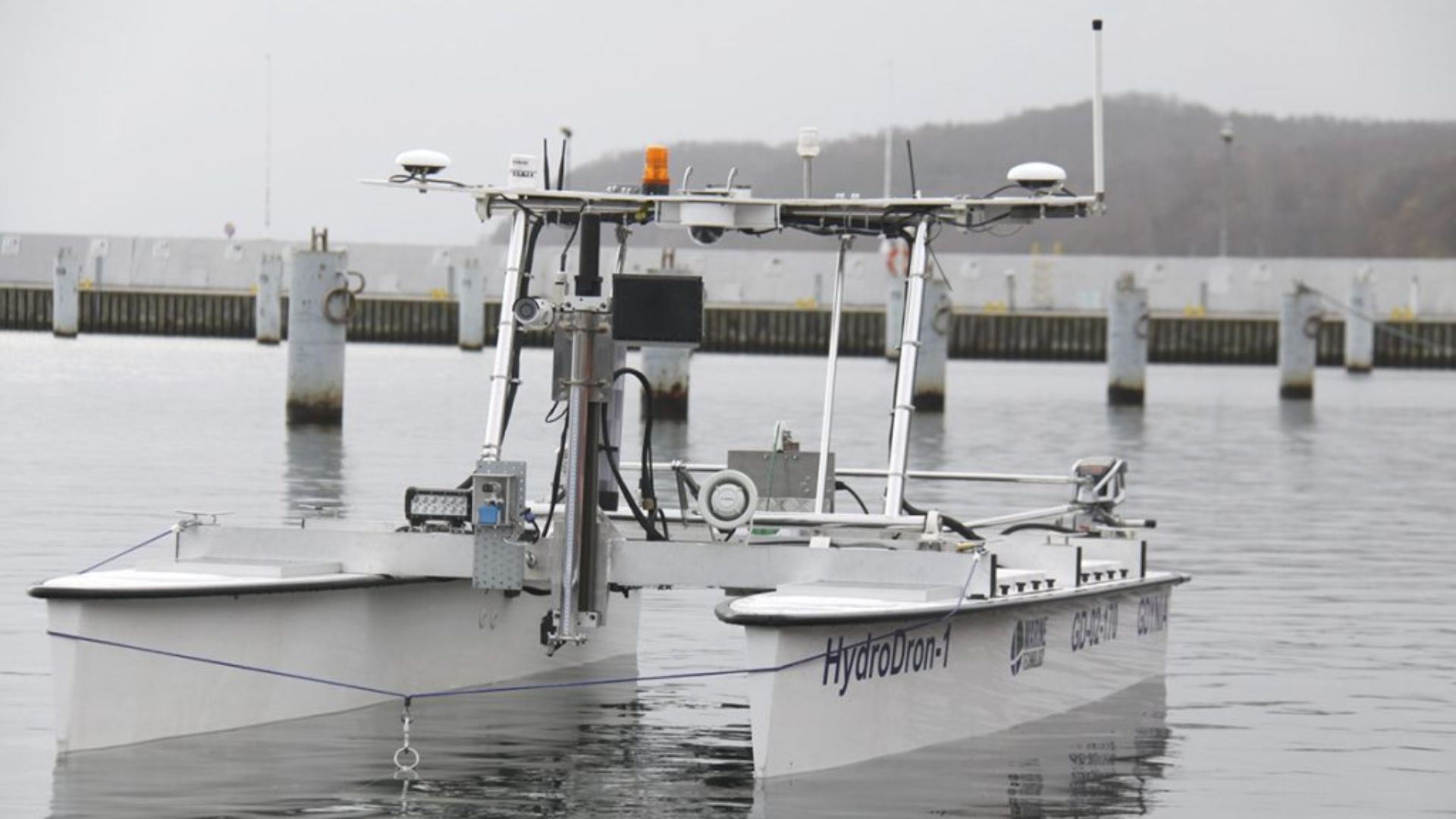
Marine Technology presented HydroDron, the first autonomous hydrographic unmanned vessel in Poland, at Baltexpo 2019. The recently finished project was co-financed by the National Centre for Research and Development and was awarded in the competition Baltexpo Golden Anchor 2019.

HydroDron Allows Surveying in Inaccessible Waters
HydroDron is an unmanned catamaran made of lightweight and durable material, with a double-hull system (4m long and 2m wide).
The engine part, equipped with two electric motors working independently of each other, provide adequate speed and maneuverability, reaching a maximum speed of over 10 knots.
This autonomous and remote-controlled floating platform dedicated to hydrographic measurements in limited waters is characterized by mobility.
It is possible to carry it in the mission area on a car trailer or a larger surface vessel and launch it from the trailer from the beach, shore, wharf, platform, or the surface vessel.
HydroDron operates in waters inaccessible or difficult for larger manned units, making their use impossible or unprofitable.
An USV Fully Equipped for Hydrography
The development of the platform’s autonomous navigation and automatic 3D hydrography systems represents a significant improvement of Marine Technology’s remotely controlled multi-purpose surface platform for operation in port areas and other restricted areas.
The platform will now be able to perform bathymetric, sonar, and other measurement missions in a fully autonomous mode, implementing adaptive trajectory planning and automatic 3D analysis of near real-time situation measurement data around the platform.
HydroDron Equipment
HydroDron integrates a wide range of measuring equipment in order to provide a multitude of different variants:
- Integrated bathymetric and sonar system 3DSS-DX-450 from Ping DSP
- Industrial computer for data acquisition Getac S410 (the main element of the hydrographic station)
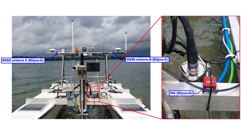
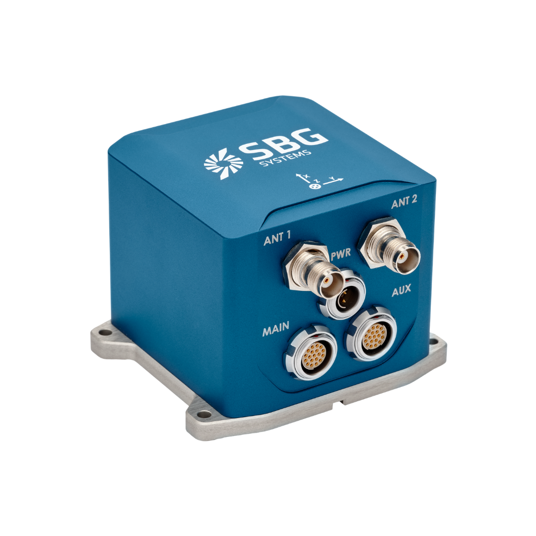
- External Dual Antenna Inertial Navigation System Ekinox2-D from SBG Systems
- Single-beam dual-frequency sonar HydroBox HD from Syqwest
- High-frequency single-beam sonar Echologger EU400
- LiDAR PUCK VLP-16 by Velodyne
A sensor system monitors the platform and its surroundings to enhance situational awareness. Moreover, it includes two vertical probes, one per hull, two video cameras, and a weather station. In addition, the system records navigation data, video from both cameras, weather conditions, battery voltage, and float depths. Furthermore, radar and two laser rangefinders at the bow and stern support the unit’s anti-collision system.
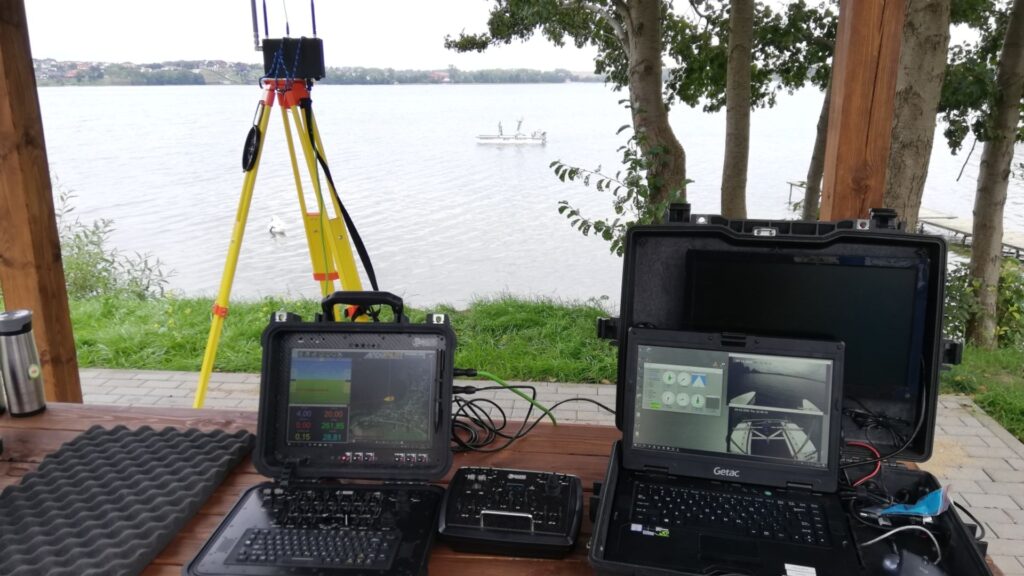
The shore station receives navigation data, managed by two consoles:
- a navigation console
- a hydrographic one with a Getac computer.
Hypack software ensures hydrographic measurements, from planning the work to developing the final product. Hydrographic data from the multibeam probe and LiDAR are recorded on board industrial computers.
The Ekinox-D Inertial Navigation System
The compact Ekinox-D Dual Antenna INS from SBG Systems integrates a survey-grade IMU with a Dual Antenna RTK GNSS receiver. Moreover, this advanced INS/GNSS provides orientation, heave, and centimeter-level positioning accuracy. Its small size, low weight, and robust IP68 enclosure make it ideal for space-constrained applications such as USVs. In addition, Ekinox sensors feature an 8 GB data logger for post-operation analysis or post-processing.
Furthermore, the system includes an easy-to-use web interface for simplified operation. Data from this inertial sensor can also be post-processed with SBG’s in-house PPK software, Qinertia.
Finally, Qinertia enhances SBG INS performance by processing inertial data with raw GNSS observables. It also provides offline RTK corrections from over 8,000 base stations in 164 countries, always kept up to date.
Ekinox-D
Ekinox-D is an all-in-one Inertial Navigation System with integrated RTK GNSS receiver ideal for applications where space is critical.
This advanced INS/GNSS comes with one or two antennas and provides orientation, heave, and centimeter-level position.
Ask a quotation for Ekinox-D
Do you have questions?
Welcome to our FAQ section! Here, you will find answers to the most common questions about our showcased applications. Moreover, if you cannot find the answer you need, please contact us directly for assistance.
What are wave measurement sensors?
Wave measurement sensors are essential tools for understanding ocean dynamics and improving safety and efficiency in marine operations. By providing accurate and timely data on wave conditions, they help inform decisions across various sectors, from shipping and navigation to environmental conservation. Wave buoys are floating devices equipped with sensors to measure wave parameters such as height, period, and direction.
They typically use accelerometers or gyroscopes to detect wave motion (e.g. wave period) and can transmit real-time data to shore-based facilities for analysis.
What is hydrographic surveying?
Hydrographic surveying is the process of measuring and mapping physical features of bodies of water, including oceans, rivers, lakes, and coastal areas. It involves collecting data related to the depth, shape, and contours of the seafloor (seafloor mapping), as well as the location of submerged objects, navigational hazards, and other underwater features (e.g. water trenches). Hydrographic surveying is crucial for various applications, including navigation safety, coastal management and coastal survey, construction, and environmental monitoring.
Hydrographic surveying involves several key components, starting with bathymetry, which measures water depth and seafloor topography using sonar systems like single-beam or multi-beam echo sounders that send sound pulses to the seafloor and measure the echo’s return time.
Accurate positioning is critical, achieved using Global Navigation Satellite Systems (GNSS) and Inertial Navigation Systems (INS) to link depth measurements to precise geographic coordinates. Additionally, water column data, such as temperature, salinity, and currents, are measured, and geophysical data is collected to detect underwater objects, obstacles, or hazards using tools like side-scan sonar and magnetometers.
What is bathymetry?
Bathymetry is the study and measurement of the depth and shape of underwater terrain, primarily focused on mapping the seafloor and other submerged landscapes. It is the underwater equivalent of topography, providing detailed insights into the underwater features of oceans, seas, lakes, and rivers. Bathymetry plays a crucial role in various applications, including navigation, marine construction, resource exploration, and environmental studies.
Modern bathymetric techniques rely on sonar systems, such as single-beam and multibeam echo sounders, which use sound waves to measure water depth. These devices send sound pulses toward the seafloor and record the time it takes for the echoes to return, calculating depth based on the speed of sound in water. Multibeam echo sounders, in particular, allow for wide swaths of the seafloor to be mapped at once, providing highly detailed and accurate seafloor representations. Frequently, a RTK + INS solution is associated to create accurately positioned 3D bathymetric representations of the seafloor.
Bathymetric data is essential for creating nautical charts, which help guide vessels safely by identifying potential underwater hazards like submerged rocks, wrecks, and sandbanks. It also plays a vital role in scientific research, helping researchers understand underwater geological features, ocean currents, and marine ecosystems.
What is a buoy used for?
A buoy is a floating device primarily used in maritime and water-based environments for several key purposes. Buoys are often placed in specific locations to mark safe passages, channels, or hazardous areas in bodies of water. They guide ships and vessels, helping them avoid dangerous spots like rocks, shallow waters, or wrecks.
They are used as anchoring points for vessels. Mooring buoys allow boats to tie up without having to drop anchor, which can be especially useful in areas where anchoring is impractical or damaging to the environment.
Instrumented buoys are equipped with sensors to measure environmental conditions like temperature, wave height, wind speed, and atmospheric pressure. These buoys provide valuable data for weather forecasting, climate research, and oceanographic studies.
Some buoys act as platforms for collecting and transmitting real-time data from the water or seabed, often used in scientific research, environmental monitoring, and military applications.
In commercial fishing, buoys mark the location of traps or nets. They also help in aquaculture, marking the locations of underwater farms.
Buoys can also mark designated areas such as no-anchoring zones, no-fishing zones, or swimming areas, helping enforce regulations on the water.
In all cases, buoys are critical for ensuring safety, facilitating marine activities, and supporting scientific research.
What is buoyancy?
Buoyancy is the force exerted by a fluid (such as water or air) that opposes the weight of an object submerged in it. It allows objects to float or rise to the surface if their density is less than that of the fluid. Buoyancy occurs because of the difference in pressure exerted on the object’s submerged portions—greater pressure is applied at lower depths, creating an upward force.
The principle of buoyancy is described by Archimedes’ principle, which states that the upward buoyant force on an object is equal to the weight of the fluid displaced by the object. If the buoyant force is greater than the object’s weight, it will float; if it is less, the object will sink. Buoyancy is essential in many fields, from marine engineering (designing ships and submarines) to the functionality of floating devices like buoys.
What is ROV ?
ROV or Remotely Operated Vehicle, is an uncrewed underwater robot designed to operate in environments that are too deep, dangerous, or otherwise inaccessible for human divers. ROVs are widely used in marine industries such as offshore oil and gas, scientific research, environmental monitoring, and naval operations. Unlike autonomous underwater vehicles (AUVs), which operate independently following pre-programmed paths, ROVs are typically tethered to a surface vessel via an umbilical cable that provides power, communication, and control signals. This tether allows a human operator on the surface to pilot the vehicle in real time, providing precise maneuvering, monitoring, and control of onboard sensors and manipulators.
ROVs are equipped with a variety of instruments depending on their mission. They commonly carry high-definition cameras for visual inspection, sonar systems for mapping and navigation, and manipulator arms for interacting with objects on the seabed. Advanced models may include specialized sensors such as environmental probes, magnetometers, and inertial navigation systems (INS) to maintain accurate positioning in challenging underwater conditions. Since GPS/GNSS signals cannot penetrate water, ROVs rely on a combination of acoustic positioning systems, Doppler velocity logs (DVLs), pressure sensors, and inertial navigation to estimate their position relative to the surface vessel or a fixed reference point. High-precision ROVs used in subsea construction or scientific research often integrate tactical-grade IMUs to ensure centimeter-level accuracy over extended operations, even in areas with poor acoustic coverage.
The design of an ROV is highly modular, allowing different payloads to be attached depending on mission requirements. Small observation-class ROVs are lightweight and portable, intended for simple visual inspections, while work-class ROVs are much larger, capable of heavy-duty tasks such as subsea construction, pipeline repair, or sample collection. ROVs provide unmatched access to underwater environments, extending human capabilities and enabling operations at depths and durations that would otherwise be impossible. In essence, an ROV is both a versatile exploration tool and a precision platform for executing complex underwater missions, bridging the gap between human oversight and remote robotic capability.
