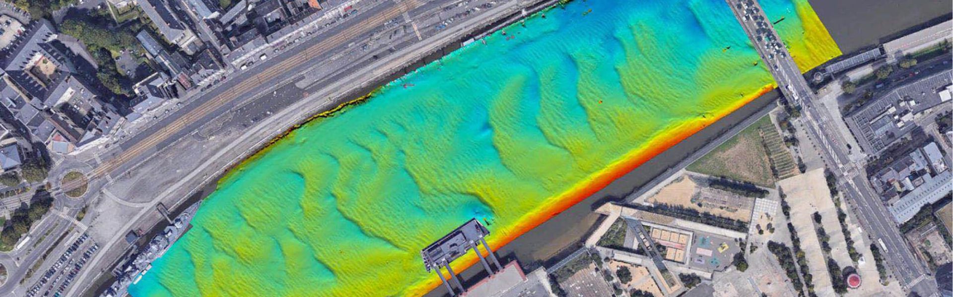
ASV equipped with Multibeam Echosounder
Cadden Demonstrates its Solution integrating an Ekinox-D Inertial Navigation System.
“The Ekinox-D is a survey-grade yet compact and precise inertial navigation system. It is the perfect INS for USV-based Bathymetry.” | Cadden
Surveying solution developed by Cadden
Our partner Cadden held its new R2D3 conference, dedicated to the latest progress in the Representation of Reality in 3 Dimensions, on June 27th, 2019.
On this occasion, they conducted an autonomous bathymetric survey of the Loire river in Nantes, France.
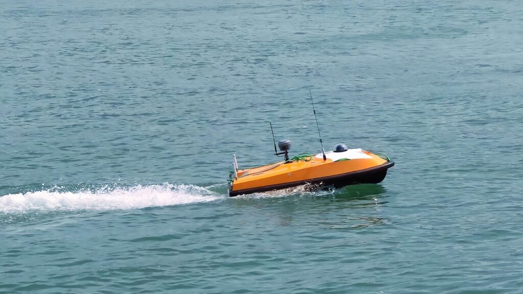
As the French representative for OceanAlpha, they equipped a SL40 Autonomous Survey Boat with a R2Sonic 2020 Multibeam Echosounder and SBG’s Ekinox-D RTK.
Cadden then presented the survey demonstration and its solution scheme at the event.
Fully equipped for bathymetry
For Multibeam bathymetry, Cadden has chosen the OceanAlpha SL40 which is a 1.6-meter-long waterjet Unmanned Surface Vehicle (USV). Payload goes up to 15 kg of survey instruments, which makes it the ideal surveying platform for smaller-sized Multibeam Echo sounder.
The solution brought by Cadden integrates:
- A R2Sonic 2020 MBES, convenient for shallow water hydrographic surveys
- A Valeport Mini SVS for higher survey accuracy
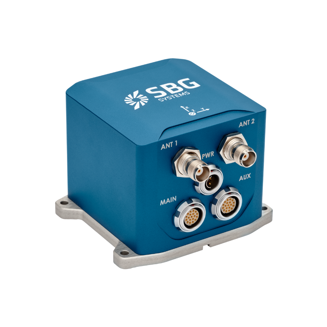
- The very compact Ekinox-D Dual Antenna Inertial Navigation System from SBG Systems. This Survey-grade IMU has an RTK Heading GNSS receiver embedded, which provides a position accuracy to the centimeter.
- Data from this inertial sensor is also post-processed with SBG’s Post-Processing software: Qinertia.
- An AML Oceanographic Base-X2
- A QPS Qinsy and Qimera
- A Velodyne Lidar, Inc. VLP16
Check out the demonstration results !

Ekinox-D
Ekinox-D is an all-in-one Inertial Navigation System with integrated RTK GNSS receiver ideal for applications where space is critical.
This advanced INS/GNSS comes with one or two antennas and provides orientation, heave, and centimeter-level position.
Ask a quotation for Ekinox-D
Do you have questions?
Welcome to our FAQ section! Here, you’ll find answers to the most common questions about the applications we showcase. If you don’t find what you’re looking for, feel free to contact us directly!
What is hydrographic surveying?
Hydrographic surveying is the process of measuring and mapping physical features of bodies of water, including oceans, rivers, lakes, and coastal areas. It involves collecting data related to the depth, shape, and contours of the seafloor (seafloor mapping), as well as the location of submerged objects, navigational hazards, and other underwater features (e.g. water trenches). Hydrographic surveying is crucial for various applications, including navigation safety, coastal management and coastal survey, construction, and environmental monitoring.
Hydrographic surveying involves several key components, starting with bathymetry, which measures water depth and seafloor topography using sonar systems like single-beam or multi-beam echo sounders that send sound pulses to the seafloor and measure the echo’s return time.
Accurate positioning is critical, achieved using Global Navigation Satellite Systems (GNSS) and Inertial Navigation Systems (INS) to link depth measurements to precise geographic coordinates. Additionally, water column data, such as temperature, salinity, and currents, are measured, and geophysical data is collected to detect underwater objects, obstacles, or hazards using tools like side-scan sonar and magnetometers.
What are wave measurement sensors?
Wave measurement sensors are essential tools for understanding ocean dynamics and improving safety and efficiency in marine operations. By providing accurate and timely data on wave conditions, they help inform decisions across various sectors, from shipping and navigation to environmental conservation. Wave buoys are floating devices equipped with sensors to measure wave parameters such as height, period, and direction.
They typically use accelerometers or gyroscopes to detect wave motion (e.g. wave period) and can transmit real-time data to shore-based facilities for analysis.
What is bathymetry?
Bathymetry is the study and measurement of the depth and shape of underwater terrain, primarily focused on mapping the seafloor and other submerged landscapes. It is the underwater equivalent of topography, providing detailed insights into the underwater features of oceans, seas, lakes, and rivers. Bathymetry plays a crucial role in various applications, including navigation, marine construction, resource exploration, and environmental studies.
Modern bathymetric techniques rely on sonar systems, such as single-beam and multibeam echo sounders, which use sound waves to measure water depth. These devices send sound pulses toward the seafloor and record the time it takes for the echoes to return, calculating depth based on the speed of sound in water. Multibeam echo sounders, in particular, allow for wide swaths of the seafloor to be mapped at once, providing highly detailed and accurate seafloor representations. Frequently, a RTK + INS solution is associated to create accurately positioned 3D bathymetric representations of the seafloor.
Bathymetric data is essential for creating nautical charts, which help guide vessels safely by identifying potential underwater hazards like submerged rocks, wrecks, and sandbanks. It also plays a vital role in scientific research, helping researchers understand underwater geological features, ocean currents, and marine ecosystems.
What is a buoy used for?
A buoy is a floating device primarily used in maritime and water-based environments for several key purposes. Buoys are often placed in specific locations to mark safe passages, channels, or hazardous areas in bodies of water. They guide ships and vessels, helping them avoid dangerous spots like rocks, shallow waters, or wrecks.
They are used as anchoring points for vessels. Mooring buoys allow boats to tie up without having to drop anchor, which can be especially useful in areas where anchoring is impractical or damaging to the environment.
Instrumented buoys are equipped with sensors to measure environmental conditions like temperature, wave height, wind speed, and atmospheric pressure. These buoys provide valuable data for weather forecasting, climate research, and oceanographic studies.
Some buoys act as platforms for collecting and transmitting real-time data from the water or seabed, often used in scientific research, environmental monitoring, and military applications.
In commercial fishing, buoys mark the location of traps or nets. They also help in aquaculture, marking the locations of underwater farms.
Buoys can also mark designated areas such as no-anchoring zones, no-fishing zones, or swimming areas, helping enforce regulations on the water.
In all cases, buoys are critical for ensuring safety, facilitating marine activities, and supporting scientific research.
What is buoyancy?
Buoyancy is the force exerted by a fluid (such as water or air) that opposes the weight of an object submerged in it. It allows objects to float or rise to the surface if their density is less than that of the fluid. Buoyancy occurs because of the difference in pressure exerted on the object’s submerged portions—greater pressure is applied at lower depths, creating an upward force.
The principle of buoyancy is described by Archimedes’ principle, which states that the upward buoyant force on an object is equal to the weight of the fluid displaced by the object. If the buoyant force is greater than the object’s weight, it will float; if it is less, the object will sink. Buoyancy is essential in many fields, from marine engineering (designing ships and submarines) to the functionality of floating devices like buoys.
