Improving aerial mapping data collection
Inertial systems, such as Inertial Measurement Units (IMUs) and Inertial Navigation Systems (INS), are crucial components in aerial surveying.
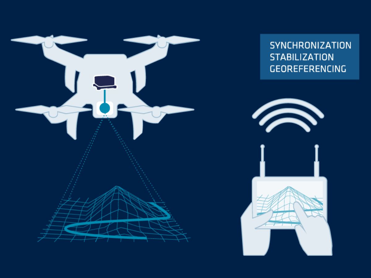
These systems provide real-time data on the aircraft’s orientation, position, and movement, allowing for precise georeferencing of collected images and sensor data. Inertial systems work alongside GNSS (Global Navigation Satellite System) to ensure that even when GNS signals are weak or unavailable, the aircraft continues to gather accurate spatial information.
One of the significant advantages of using inertial systems in aerial surveying is their ability to compensate for the aircraft’s movements, such as pitch, roll, and yaw, which can affect the quality of the collected data. By continuously measuring the aircraft’s attitude, inertial systems correct any distortions in the imagery or sensor data, ensuring that the results are consistent and accurate. This is particularly important in applications like LiDAR, where slight inaccuracies can result in substantial errors in the final dataset.
Moreover, inertial systems enhance the efficiency of aerial surveys by allowing for faster data acquisition without compromising accuracy. Surveyors can fly at higher altitudes and faster speeds, covering more ground in less time, which reduces operational costs while still achieving high-quality results.
Discover our solutions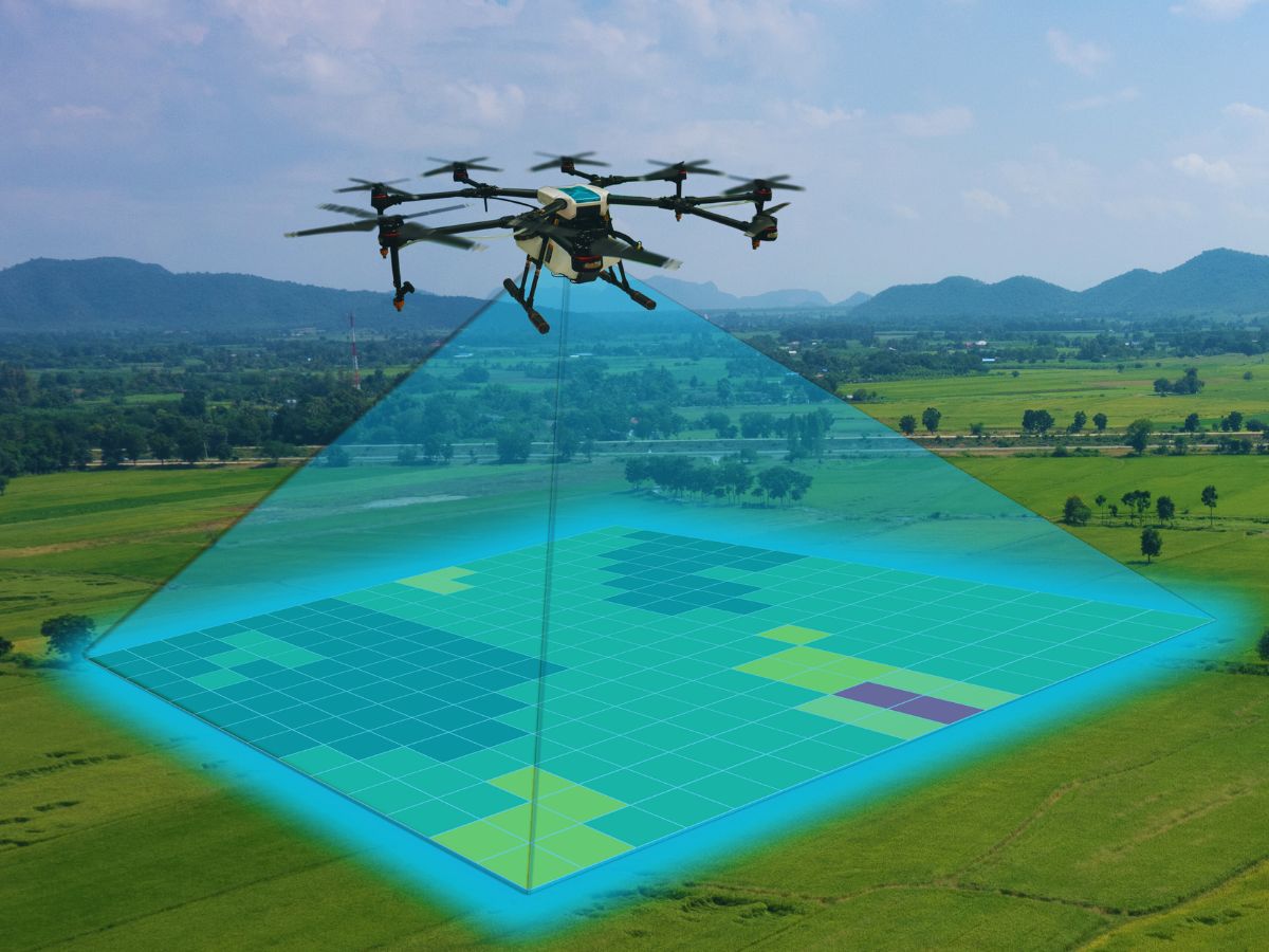
Applications of inertial systems in aerial mapping
Inertial systems play a critical role in various aerial mapping applications. For example, corridor mapping involves surveying long, narrow areas such as roads, railways, or pipelines. IMUs and INS help keep the data accurately aligned along the mapped route.
This enables engineers and planners to make precise calculations for infrastructure development and maintenance.
In forestry and agriculture, inertial systems help drones or aircraft fly over large areas to collect crucial data. This data supports resource management, crop monitoring, and environmental conservation. Accurate mapping of forests and fields improves decisions on land use, irrigation, and harvesting. These insights boost productivity while reducing environmental impact.
In construction and urban planning, aerial surveys supported by inertial systems provide detailed topographic maps and 3D models of the terrain. These datasets are essential for designing and implementing large-scale projects, as they offer a clear understanding of the land’s features and potential challenges. Additionally, inertial systems enable real-time data processing, which speeds up project timelines and enhances decision-making.
Aerial surveying real-time positioning and navigation
In aerial surveying, the combination of INS and GNSS offers a robust solution for real-time positioning and navigation. These systems work in tandem to provide continuous, high-precision data, regardless of environmental conditions. In GNSS-denied environments, such as dense forests or heavy cloud cover, inertial systems maintain accurate positioning. They ensure the survey continues smoothly, even without satellite signals.
INS technology determines the aircraft’s position using accelerometers and gyroscopes. These sensors track acceleration and rotational movement. When combined with GNSS data, this creates a complete view of the aircraft’s flight path and position. This precise positioning ensures that all collected data is accurately georeferenced.
Real-time positioning is crucial in dynamic environments where conditions change quickly, like disaster zones (e.g. wildfires) or active construction sites. It enables on-the-fly adjustments to flight paths and data collection settings. This flexibility helps surveyors capture the most relevant information. As a result, the overall quality and usefulness of the survey data improves.

Discover our solutions for aerial survey
Our motion and navigation products are tailored to the needs of aerial surveying applications. Our high-performance INS solutions with GNSS provide real-time positioning, navigation, and orientation. They ensure excellent accuracy and reliability for aerial surveys.

Quanta Extra
Qinertia GNSS-INS
Surveying applications brochure
Get our brochure delivered straight to your inbox!
Case studies
Learn how our products have been successfully integrated into aerial surveying applications worldwide.
Our case studies show how SBG Systems’ inertial systems improve accuracy, reliability, and efficiency in aerial mapping projects.
From large-scale infrastructure surveys to environmental monitoring, our inertial systems have proven their value in a wide range of applications.


They talk about us
Hear first hand, from the innovators and clients who have adopted our technology.
Their testimonials and success stories illustrate the significant impact our sensors have in practical UAV navigation applications.
Explore other surveying applications
Discover the full potential of our advanced inertial navigation solutions across a wide range of surveying applications. Our technology supports land, air, and sea operations. It ensures reliable data, high precision, and consistent performance in any environment.
Do you have questions?
Welcome to our FAQ section! Here, you’ll find answers to the most common questions about the applications we showcase. If you don’t find what you’re looking for, feel free to contact us directly!
How can I combine inertial systems with a LIDAR for drone mapping?
Combining SBG Systems’ inertial systems with LiDAR for drone mapping enhances accuracy and reliability in capturing precise geospatial data.
Here’s how the integration works and how it benefits drone-based mapping:
- A remote sensing method that uses laser pulses to measure distances to the Earth’s surface, creating a detailed 3D map of the terrain or structures.
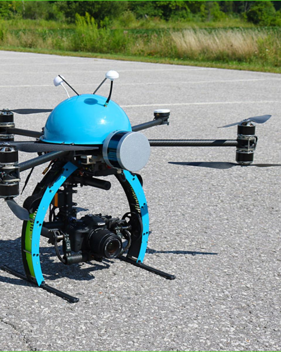
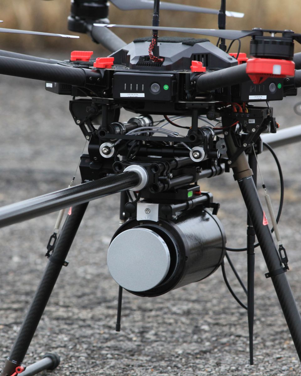
- SBG Systems INS combines an Inertial Measurement Unit (IMU) with GNSS data to provide accurate positioning, orientation (pitch, roll, yaw), and velocity, even in GNSS-denied environments.
SBG’s inertial system is synchronized with the LiDAR data. The INS accurately tracks the drone’s position and orientation, while the LiDAR captures the terrain or object details below.
By knowing the precise orientation of the drone, the LiDAR data can be accurately positioned in 3D space.
The GNSS component provides global positioning, while the IMU offers real-time orientation and movement data. The combination ensures that even when the GNSS signal is weak or unavailable (e.g., near tall buildings or dense forests), the INS can continue to track the drone’s path and position, allowing for consistent LiDAR mapping.
What is georeferencing in aerial surveying?
Georeferencing is the process of aligning geographic data (such as maps, satellite images, or aerial photography) to a known coordinate system so that it can be accurately placed on the Earth’s surface.
This allows the data to be integrated with other spatial information, enabling precise location-based analysis and mapping.
In the context of surveying, georeferencing is essential for ensuring that the data collected by tools like LiDAR, cameras, or sensors on drones is accurately mapped to real-world coordinates.
By assigning latitude, longitude, and elevation to each data point, georeferencing ensures that the captured data reflects the exact location and orientation on the Earth, which is crucial for applications such as geospatial mapping, environmental monitoring, and construction planning.
Georeferencing typically involves using control points with known coordinates, often obtained through GNSS or ground surveying, to align the captured data with the coordinate system.
This process is vital for creating accurate, reliable, and usable spatial datasets.
What is photogrammetry?
Photogrammetry is the science and technique of using photographs to measure and map distances, dimensions, and features of objects or environments. By analyzing overlapping images taken from different angles, photogrammetry allows for the creation of accurate 3D models, maps, or measurements. This process works by identifying common points in multiple photographs and calculating their positions in space, using principles of triangulation.
Photogrammetry is widely used in various fields, such as:
- Photogrammetry topographic mapping: Creating 3D maps of landscapes and urban areas.
- Architecture and engineering: For building documentation and structural analysis.
- Photogrammetry in archaeology: Documenting and reconstructing sites and artifacts.
- Aerial photogrammetry surveying: For land measurement and construction planning.
- Forestry and agriculture: Monitoring crops, forests, and land use changes.
When photogrammetry is combined with modern drones or UAVs (unmanned aerial vehicles), it enables the rapid collection of aerial images, making it an efficient tool for large-scale surveying, construction, and environmental monitoring projects.
Whats an IMU ?
An Inertial Measurement Unit (IMU) is a compact sensor module that measures the motion and orientation of a platform by capturing its linear accelerations and angular rotation rates. At its core, an IMU integrates three accelerometers and three gyroscopes arranged along orthogonal axes to provide six degrees of measurement.
Accelerometers sense how the platform accelerates in space, while gyroscopes track how it rotates. By processing these measurements together, an IMU delivers precise information about changes in velocity, attitude, and heading without relying on any external signals. This makes IMUs essential for navigation in environments where GPS is unavailable, unreliable, or intentionally denied. Their performance depends heavily on sensor quality, calibration, and how well errors—such as biases, noise, scale factors, and misalignments—are controlled.
High-grade IMUs include advanced calibration, thermal compensation, vibration filtering, and bias stability mechanisms to ensure that errors do not accumulate rapidly over time. Because of these characteristics, IMUs are used across a wide range of applications—from UAVs, loitering munitions, and autonomous vehicles to AUVs, robotics, and industrial stabilization systems—providing robust, continuous awareness of motion and orientation even in the harshest operational conditions.
