World’s first small-scale Topographic and Bathymetric LiDAR system for UAVs
Direct Geo-referencing Solution for UAV-based LiDAR.
“We needed a motion and navigation solution for our LiDAR. Our requirements included high accuracy along with low size, weight, and power.” | Andy G., Director of Lidar Systems with ASTRALiTe
World’s first small-scale topo & bathy LiDAR
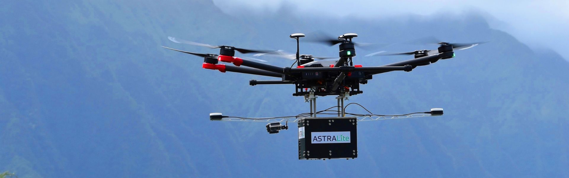
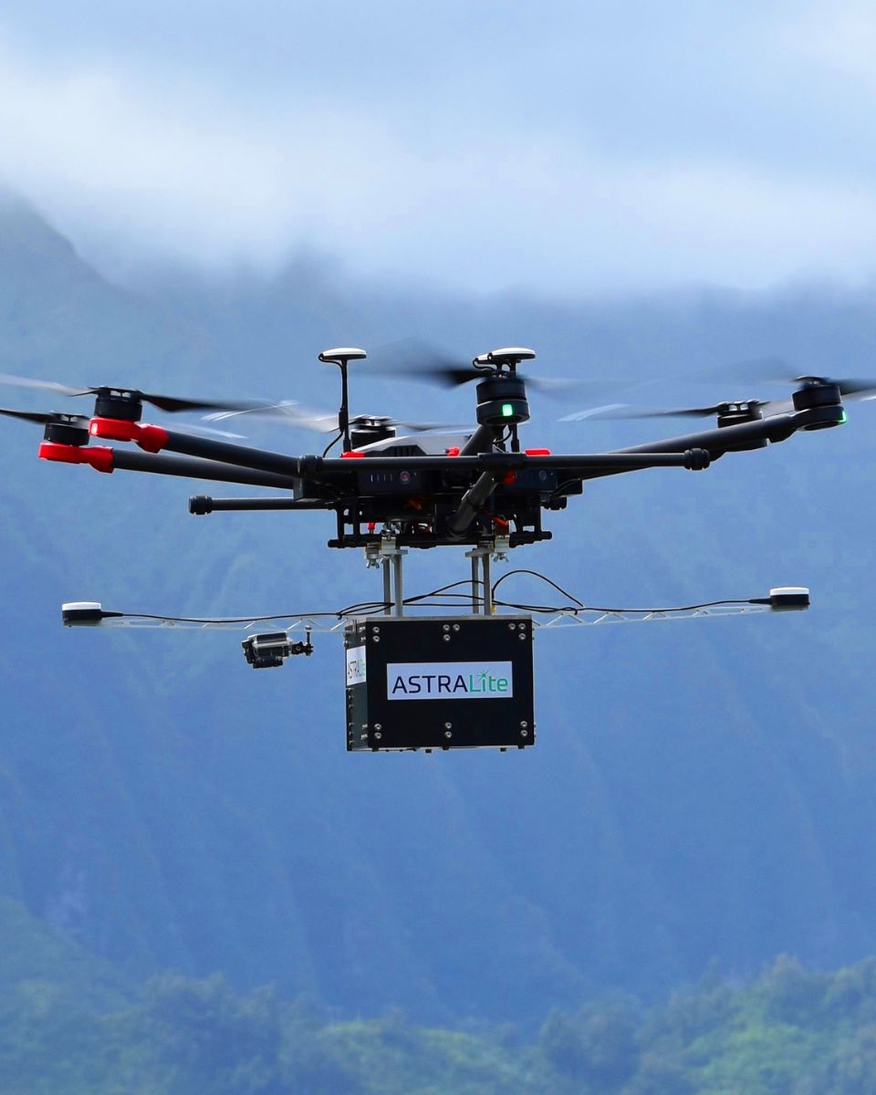
EDGE LiDAR is the world’s first small-scale topographic and bathymetric scanning LiDAR that can detect small underwater objects, measure shallow water depth, and survey critical underwater infrastructure from a small UAV platform.
EDGE LiDAR penetrates water surfaces at depths from 0–5 meters. Moreover, it is fully self-contained with its own INS/GNSS, battery, and onboard computer. In addition, it weighs about 5 kg and mounts easily on UAV systems. Finally, it enables faster, safer, and more accurate bathymetric surveys.
SBG’s PPK Direct Geo-referencing Solution
“We needed a motion and navigation solution for our LiDAR. Our requirements included high accuracy along with low size, weight, and power” , explains Andy Gisler, Director of Lidar Systems with ASTRALiTe. In addition, the system needed to be able to apply a PPK correction to the LiDAR data to provide higher accuracy results to ASTRALiTe’s customers.
Quanta, the dual antenna geo-referencing solution
The company chose the new geo-referencing solution from SBG Systems named Quanta. This Inertial Navigation Systems (INS) is specially designed to be integrated into mobile mapping systems. “The weight of the INS solution was especially important to us“, adds Andy.
ASTRALiTe’s system is to be flown on most UAVs, where light payload capacities are required for UAV compatibility. The ability to use two GPS antennas was key in our choice as we required good heading knowledge at slow flight speeds.
All Quanta Series range directly and precisely geotags the point cloud in real-time and provides even higher performance in post-processing.
Qinertia Post-processing Software
Qinertia, SBG’s post-processing software gives access to offline RTK corrections from more than 7,000 base stations located in 164 countries.

Processing inertial data and raw GNSS observables in forward and backward directions greatly improves trajectory and orientation. Moreover, this dual processing ensures higher reliability and accuracy. This advanced software also computes your base station position to quickly get your project to the centimeter accuracy.
“We are very pleased with both the Quanta and with the Qinertia software package. SBG helped us work through the integration and data processing.” | Andy G., Director of Lidar Systems with ASTRALiTe
About ASTRALiTe
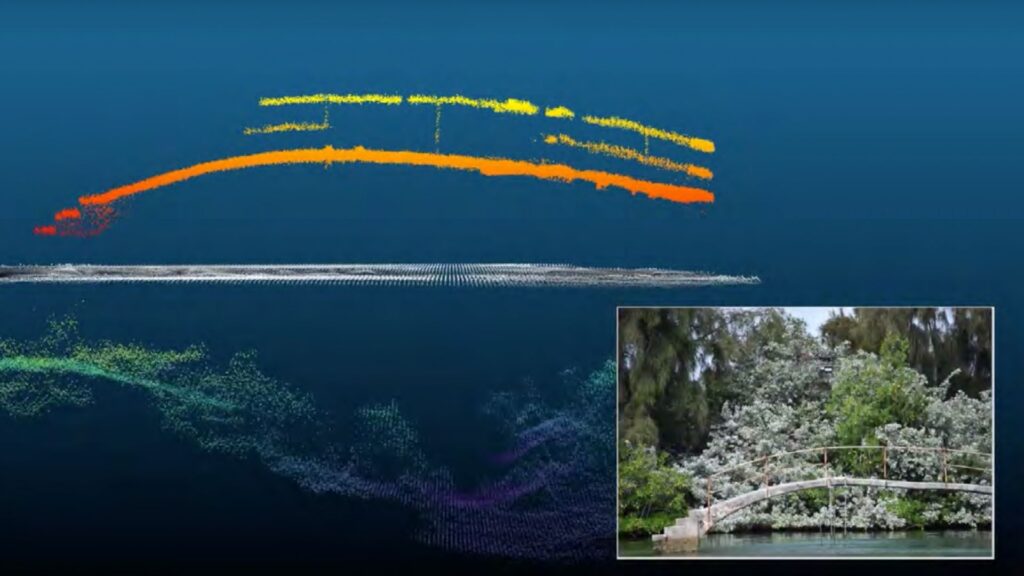
ASTRALiTe is now part of Orion Space Solutions. The EDGE LiDAR system provides high-definition measurements both above and below the water surface and accurately measures the transition from land to water.
Additionally, this equipment provides simultaneous water and bottom surface detection at sub-centimeter accuracy and precision from shore through shallow waters — an industry first.

Quanta Plus
Quanta Plus combines a tactical MEMS IMU with a high-performance GNSS receiver to get reliable position and attitude, even in harshest GNSS environments.
Its miniature OEM form factor and stellar performance make it ideal for mapping applications such as UAV dedicated to surveying or mobile mapping.
Quanta Plus also benefits from easy integration within our post-processing software: Qinertia.
Ask a quotation for Quanta Plus
Do you have questions?
Welcome to our FAQ section! Here, you’ll find answers to the most common questions about the applications we showcase. If you don’t find what you’re looking for, feel free to contact us directly!
What are wave measurement sensors?
Wave measurement sensors are essential tools for understanding ocean dynamics and improving safety and efficiency in marine operations. By providing accurate and timely data on wave conditions, they help inform decisions across various sectors, from shipping and navigation to environmental conservation. Wave buoys are floating devices equipped with sensors to measure wave parameters such as height, period, and direction.
They typically use accelerometers or gyroscopes to detect wave motion (e.g. wave period) and can transmit real-time data to shore-based facilities for analysis.
What is bathymetry?
Bathymetry is the study and measurement of the depth and shape of underwater terrain, primarily focused on mapping the seafloor and other submerged landscapes. It is the underwater equivalent of topography, providing detailed insights into the underwater features of oceans, seas, lakes, and rivers. Bathymetry plays a crucial role in various applications, including navigation, marine construction, resource exploration, and environmental studies.
Modern bathymetric techniques rely on sonar systems, such as single-beam and multibeam echo sounders, which use sound waves to measure water depth. These devices send sound pulses toward the seafloor and record the time it takes for the echoes to return, calculating depth based on the speed of sound in water. Multibeam echo sounders, in particular, allow for wide swaths of the seafloor to be mapped at once, providing highly detailed and accurate seafloor representations. Frequently, a RTK + INS solution is associated to create accurately positioned 3D bathymetric representations of the seafloor.
Bathymetric data is essential for creating nautical charts, which help guide vessels safely by identifying potential underwater hazards like submerged rocks, wrecks, and sandbanks. It also plays a vital role in scientific research, helping researchers understand underwater geological features, ocean currents, and marine ecosystems.
What is a buoy used for?
A buoy is a floating device primarily used in maritime and water-based environments for several key purposes. Buoys are often placed in specific locations to mark safe passages, channels, or hazardous areas in bodies of water. They guide ships and vessels, helping them avoid dangerous spots like rocks, shallow waters, or wrecks.
They are used as anchoring points for vessels. Mooring buoys allow boats to tie up without having to drop anchor, which can be especially useful in areas where anchoring is impractical or damaging to the environment.
Instrumented buoys are equipped with sensors to measure environmental conditions like temperature, wave height, wind speed, and atmospheric pressure. These buoys provide valuable data for weather forecasting, climate research, and oceanographic studies.
Some buoys act as platforms for collecting and transmitting real-time data from the water or seabed, often used in scientific research, environmental monitoring, and military applications.
In commercial fishing, buoys mark the location of traps or nets. They also help in aquaculture, marking the locations of underwater farms.
Buoys can also mark designated areas such as no-anchoring zones, no-fishing zones, or swimming areas, helping enforce regulations on the water.
In all cases, buoys are critical for ensuring safety, facilitating marine activities, and supporting scientific research.
What is buoyancy?
Buoyancy is the force exerted by a fluid (such as water or air) that opposes the weight of an object submerged in it. It allows objects to float or rise to the surface if their density is less than that of the fluid. Buoyancy occurs because of the difference in pressure exerted on the object’s submerged portions—greater pressure is applied at lower depths, creating an upward force.
The principle of buoyancy is described by Archimedes’ principle, which states that the upward buoyant force on an object is equal to the weight of the fluid displaced by the object. If the buoyant force is greater than the object’s weight, it will float; if it is less, the object will sink. Buoyancy is essential in many fields, from marine engineering (designing ships and submarines) to the functionality of floating devices like buoys.
What is hydrographic surveying?
Hydrographic surveying is the process of measuring and mapping physical features of bodies of water, including oceans, rivers, lakes, and coastal areas. It involves collecting data related to the depth, shape, and contours of the seafloor (seafloor mapping), as well as the location of submerged objects, navigational hazards, and other underwater features (e.g. water trenches). Hydrographic surveying is crucial for various applications, including navigation safety, coastal management and coastal survey, construction, and environmental monitoring.
Hydrographic surveying involves several key components, starting with bathymetry, which measures water depth and seafloor topography using sonar systems like single-beam or multi-beam echo sounders that send sound pulses to the seafloor and measure the echo’s return time.
Accurate positioning is critical, achieved using Global Navigation Satellite Systems (GNSS) and Inertial Navigation Systems (INS) to link depth measurements to precise geographic coordinates. Additionally, water column data, such as temperature, salinity, and currents, are measured, and geophysical data is collected to detect underwater objects, obstacles, or hazards using tools like side-scan sonar and magnetometers.
What does MEMS mean?
MEMS stands for Micro-Electro-Mechanical Systems. It refers to miniaturized devices that integrate mechanical elements, sensors, actuators, and electronics on a common silicon substrate through microfabrication technology. MEMS are tiny mechanicals built on a chip that can sense, control, and actuate at a microscopic scale. They are widely used in IMUs, pressure sensors, microphones, accelerometers, gyroscopes, medical devices, and automotive systems.
