
The ambiguity resolution in precise point positioning technology (PPP) is a method that resolves integer ambiguities in carrier phase measurements. The primary objective is to advance PPP from centimeter-level accuracy to millimeter-level reliability. The unlocking of these integer values enables PPP to enhance positioning precision and reduce convergence times. The approach that combines PPP with ambiguity resolution (AR), often called PPP-AR, leverages carefully modeled phase and code biases as well as high-fidelity satellite clock products.
The process of ambiguity resolution serves to reduce uncertainties and enables the estimator to treat phase measurements as fixed integers. This, in turn, has the effect of enhancing reliability and accuracy. We have investigated the interoperability and cross-validation of phase bias products generated by multiple analysis centres. The aim of this analysis is to encourage consistent standards, facilitate the combination of results and promote real-time implementation.
In practice, the resolution of ambiguity within PPP has been shown to accelerate convergence, improve fix rates, and strengthen position integrity, even in challenging signal conditions. As GNSS constellations expand and modelling techniques improve, PPP with ambiguity resolution is emerging as a key tool for high-precision applications, ranging from surveying to autonomous navigation.
SBG Systems has developed a new technology called Orbi AR (Ambiguity Resolution), that delivers centimeter-level accuracy with GNSS without relying on local reference stations or dense ground infrastructure.
Why use Orbi AR rather than RTK?
In this section we will examine the critical factors—including speed of deployment, operational resilience, and user experience—that are shifting the balance, providing a clear rationale for choosing the versatility and accessibility of Orbi AR over the conventional constraints of RTK in modern, complex worksites.
RTK – Differential GNSS
RTK works by having two receivers:
- A base station receiver is set up at a known, fixed location, it calculates errors by comparing its known position to the GNSS signal it receives.
- A rover (static/kinematic) which receives the error corrections from a nearby base station receiver and applies them to its own signal to get a highly accurate relative position.
The accuracy is very high, but the rover must be relatively close to the base station (typically 10 to 30 km depending on atmospheric conditions), because many errors (like atmospheric delays) are local.
Orbi AR – Precise Point Positioning
Instead of using a single local base station to find relative errors, Orbi AR uses globally available correction data to calculate its own absolute position with high accuracy, completely independently. Global correction includes highly accurate satellite orbit and clock information, as well as models for atmospheric delays.
| Feature | Orbi AR | RTK |
|---|---|---|
| Local base station | Not needed | Necessary |
| Coverage | Global | Local (Single base within 30km; VRS within 80km) |
| Accuracy | Static 2-5cm in 2 sigma Kinematic 2-3cm in 1 sigma | Centimeter (cm) |
| Setup | Simple (just one receiver) | Complex (requires local base setup) |
To put it in simple terms, you can think of the difference, like two students preparing for a test. RTK is like a student taking private tutoring, where one has already the right answer and uses his experience to help the other correct mistakes.
Orbi AR, on the other hand, is like a single student working alone but carefully checking their answers against a book. While the private tutor may be slightly more accurate, it is much harder to set up and more expensive. And while both approaches lead to accurate results, the way corrections are obtained — through a nearby tutor (RTK) or a globally available book (PPP) — is what sets them apart.
How does Orbi AR work?
A standard GNSS receiver is affected by several significant errors:
- Satellite Orbit Errors: The satellite isn’t exactly where its broadcast message says it is.
- Satellite Clock Errors: The satellite’s atomic clock has tiny, but significant, timing errors.
- Atmospheric Delays: The ionosphere and troposphere slow down and bend the GNSS signals.
These transmission errors and timing errors combine to produce inaccuracies in the receiver’s calculated position. For further explanation, see GNSS and their error sources and effect of atmospheric errors on RTK and PPK processing.
The core principle of Orbi AR is to refine the above errors using precise correction data:
- The International GNSS Service-IGS calculates the exact orbit and exact clock error for every satellite with extreme precision.
- A Global Reference Stations Network operates across all regions and applies complex algorithms for orbit determination and satellite phase bias estimation.
- Once the phase bias is generated, a dedicated verification stage is operated at several control stations, controlling each satellite measurement used with the corrections set.
- Uses dual-frequency GNSS observations to mitigate ionospheric delay, obtain ionospheric free measurements without replying to external ionospheric models
- Advanced Modeling is applied to estimate and resolve mathematically the delay from troposphere.

Key Benefits of Orbi AR
Orbi AR represents a fundamental advancement in how precise geospatial data is collected, visualized, and utilized in the field, moving far beyond the traditional constraints of satellite-only positioning. The following are the key benefits of Orbi AR:
- Global coverage: achieving high accuracy in the middle of the ocean, a desert, or any remote location without needing a local base station.
- High accuracy: delivering centimeter level positioning [Test report coming soon]
- Consistency across regions: provide uniform accuracy worldwide.
- Fast convergence time: modern technique reduces the time required to reach centimeter-level accuracy
- Scalability: ideal for mass-market and global applications since no local reference stations are required.
- Cost-effectiveness: reduce reliance on dense ground-based correction networks, lowering infrastructure costs.
Orbi AR in Qinertia software
Qinertia, the Post Processing software, takes Orbi AR to the next level by combining it with Qinertia’s Geodesy Engine and processing technologies.
Geodesy Engine: Transforming Orbi AR accuracy into local context
While Orbi AR solutions deliver highly accurate positions, a significant challenge remains for end-users: translating these results from ITRF 2020 into a local datum for comparison with known reference points. This crucial step often requires complex geodetic transformations, posing a high risk of error for non-experts.
Qinertia directly addresses this challenge with its built-in geodesy engine. This engine features a comprehensive database of public transformations, allowing for seamless and accurate coordinate conversion. By handling all datum transformations internally, Qinertia’s engine eliminates a major source of potential error. It ensures that PPP-derived positions are automatically and correctly expressed in the user’s desired coordinate system, making the entire workflow from raw data to usable, localized results both simpler and more reliable.
Processing Technology: Fusing Orbi AR with IMU for unmatched reliability
Qinertia’s processing core is engineered to maximize the reliability of Orbi AR, it employs forward, backward and merge technology, which improves convergence time, reduces noise, and strengthens reliability.

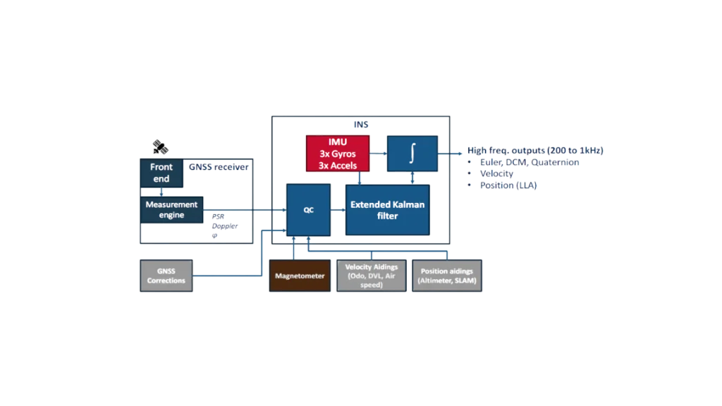
Additionally, the processing mode tight coupling PPP fuses the raw measurements from GNSS receiver and combines them with an IMU at a fundamental level for a more robust and continuous navigation solution. Tightly coupling with an IMU provides additional constraints, helping reduce convergence times and significantly speeding up reconvergence after signal loss.
Orbi AR in Qinertia Cloud
Qinertia Cloud is an advanced cloud-based GNSS post-processing web platform, powered by Qinertia. Leveraging state-of-the-art Orbi AR technology, Qinertia Cloud transforms your raw GNSS data into high-precision results directly in your web browser.
Discover Qinertia Cloud