Ellipse used for affordable multibeam solution
Mini RTK INS/GNSS for cost-effective, professional survey, and mapping multibeam sounder solutions.
” We required a cost-effective and high-precision position and motion solution. It needed to be able to combine with our WASSP multibeam technology so we could meet the high level of accuracy our customers expect “ – Bart Slingerland, Product Owner at WASSP
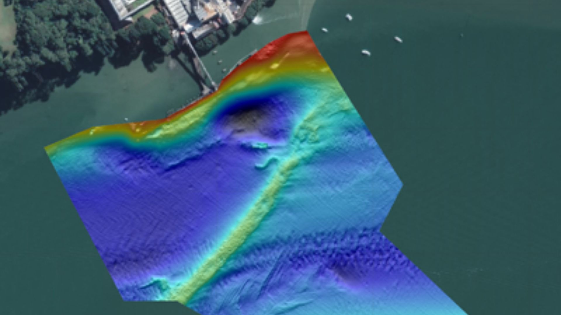
WASSP™ Multibeam Sounder technology redefines seafloor profiling, offering unprecedented speed and precision.
Engineered through extensive research and development, this advanced system profiles the seabed up to 100 times faster than traditional single-beam echo sounders.
Users gain an unparalleled view of what lies beneath their vessel, with exceptional accuracy and resolution—all at a significantly reduced cost.
With real-time 3D mapping, WASSP provides precise profiles spanning a 120° port-to-starboard range, capturing detailed images of the water column and seafloor. From artifacts and shipwrecks to fish schools and foreign objects, this cutting-edge technology reveals underwater features like never before.
WASSP is a flagship product of Electronic Navigation Limited (ENL), a global leader in marine electronics with over 75 years of experience. ENL’s dedication to innovation has consistently delivered transformative solutions for the maritime industry.
Designed for efficiency and ease of use, WASSP Multibeam Sounders empower users with cost-effective tools that simplify life at sea while unlocking new possibilities for exploration, fishing, and navigation.
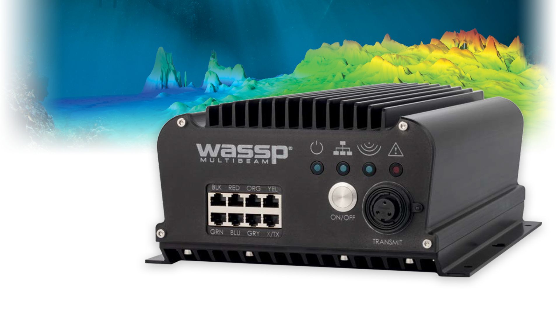
New WASSP S3r multibeam sonar
Mini RTK INS/GNSS : The new WASSP S3r is one of the world’s most cost-effective, professional survey and mapping multibeam sounder solutions.
It combines data from a multibeam sounder transducer with 224 beams covering 120° degrees swath port-to-starboard along with position, heading, and motion to create an accurate bathymetric map of underwater features for various survey situations and environmental conditions.
WASSP S3r is able to survey area up to 10 times faster than a single-beam sounder.
With the very high requirements hydrographic surveying has for accuracy, WASSP needed a solution for RTK + INS that could allow the sounder to create accurately positioned 3D bathymetric representations of the seafloor, down to centimeter accuracy with minimal passes.
This demand combined with the complexities of tide, and boat movement mean that in order to get usable position and motion data, a dual antenna system was required.
The company made multiple test scenarios from which the SBG Ellipse-D Inertial Navigation System came out as the best choice based on accuracy of consecutive test mapping.
“We required a cost-effective and high-precision position and motion solution. It needed to be able to combine with our WASSP multibeam technology so we could meet the high level of accuracy our customers expect ” explains Bart Slingerland, Product Owner at WASSP.
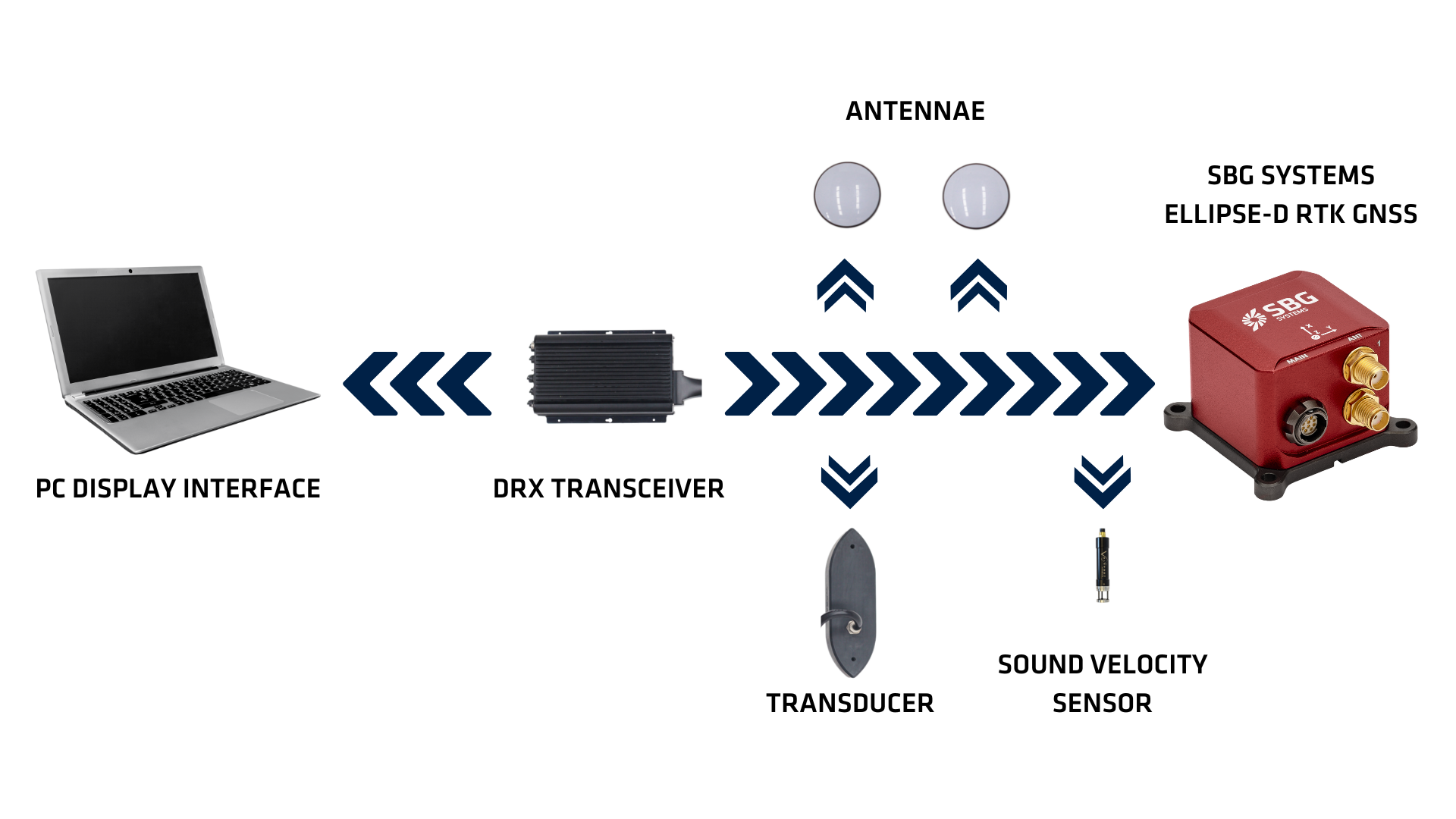
WASSP integrated the Ellipse-D into its S3Pr portable survey package, prioritizing size, weight, and cost. SBG’ Ellipse-D fits in a covered housing for quick setup on small vessels and interfaces with WASSP DRX and CDX.
Ellipse, the smallest RTK INS on the market
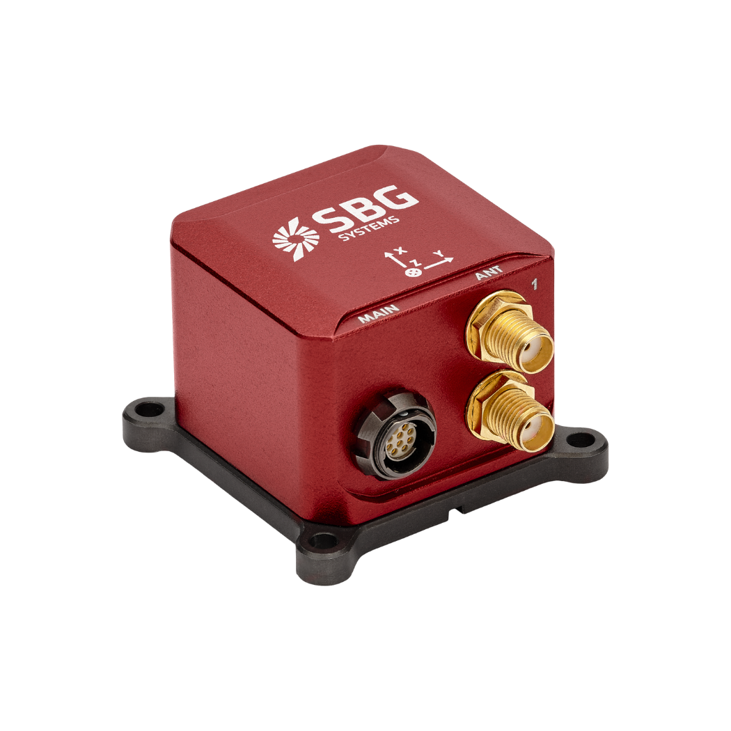
The new Ellipse-D has been launched in June 2020. This miniature Inertial Navigation System (INS) provides RTK position, 0.05° attitude, and dual antenna heading. It also outputs a 5cm heave, that adjusts automatically to the wave period.
This sensor easily integrates into marine projects, thanks to its compatibility with TSS1, PASHR, and INDYN protocols.
Ellipse is the smallest heave sensor at this level of performance, and the OEM version allows the tightest integrations. “We are very proud to be part of WASSP S3r and S3Pr.
WASSP innovative solutions makes multibeam sonar technology available to the largest professionals” to conclude Thibault Bonnevie, CEO of SBG Systems.
“WASSP has also incorporated the Ellipse-D into its S3Pr portable survey package where size, weight, and cost were also key factors in the final solution. “
Ellipse-D
The Ellipse-D is an inertial navigation system integrating a dual antenna and dual frequency RTK GNSS that is compatible with our Post-Processing software Qinertia.
Designed for robotic and geospatial applications, it can fuse Odometer input with Pulse or CAN OBDII for enhanced dead-reckoning accuracy.
Ask a quotation for Ellipse-D
Do you have questions?
Welcome to our FAQ section! Here, you’ll find answers to the most common questions about the applications we showcase. If you don’t find what you’re looking for, feel free to contact us directly!
What are wave measurement sensors?
Wave measurement sensors are essential tools for understanding ocean dynamics and improving safety and efficiency in marine operations. By providing accurate and timely data on wave conditions, they help inform decisions across various sectors, from shipping and navigation to environmental conservation. Wave buoys are floating devices equipped with sensors to measure wave parameters such as height, period, and direction.
They typically use accelerometers or gyroscopes to detect wave motion (e.g. wave period) and can transmit real-time data to shore-based facilities for analysis.
What is bathymetry?
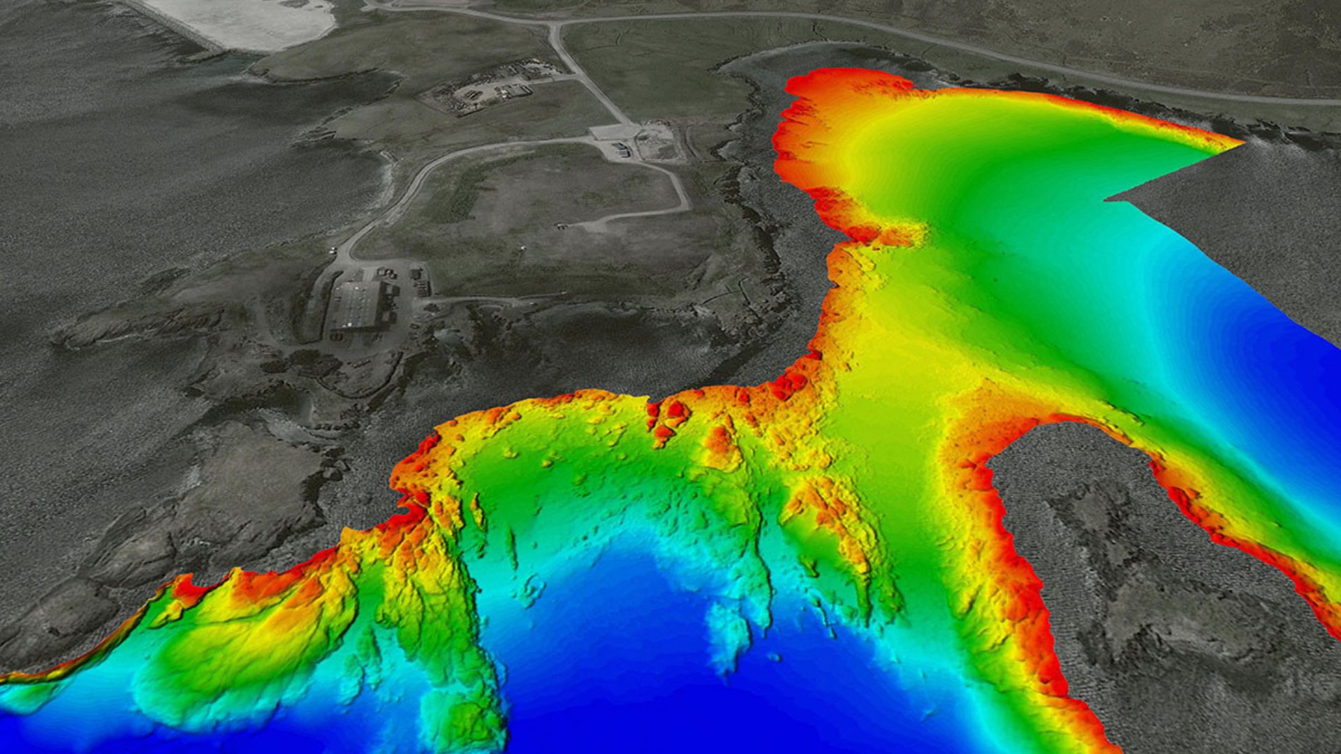
Bathymetry is the study and measurement of the depth and shape of underwater terrain, primarily focused on mapping the seafloor and other submerged landscapes. It is the underwater equivalent of topography, providing detailed insights into the underwater features of oceans, seas, lakes, and rivers. Bathymetry plays a crucial role in various applications, including navigation, marine construction, resource exploration, and environmental studies.
Modern bathymetric techniques rely on sonar systems, such as single-beam and multibeam echo sounders, which use sound waves to measure water depth. These devices send sound pulses toward the seafloor and record the time it takes for the echoes to return, calculating depth based on the speed of sound in water. Multibeam echo sounders, in particular, allow for wide swaths of the seafloor to be mapped at once, providing highly detailed and accurate seafloor representations. Frequently, a RTK + INS solution is associated to create accurately positioned 3D bathymetric representations of the seafloor.
Bathymetric data is essential for creating nautical charts, which help guide vessels safely by identifying potential underwater hazards like submerged rocks, wrecks, and sandbanks. It also plays a vital role in scientific research, helping researchers understand underwater geological features, ocean currents, and marine ecosystems.
What is a buoy used for?
A buoy is a floating device primarily used in maritime and water-based environments for several key purposes. Buoys are often placed in specific locations to mark safe passages, channels, or hazardous areas in bodies of water. They guide ships and vessels, helping them avoid dangerous spots like rocks, shallow waters, or wrecks.
They are used as anchoring points for vessels. Mooring buoys allow boats to tie up without having to drop anchor, which can be especially useful in areas where anchoring is impractical or damaging to the environment.
Instrumented buoys are equipped with sensors to measure environmental conditions like temperature, wave height, wind speed, and atmospheric pressure. These buoys provide valuable data for weather forecasting, climate research, and oceanographic studies.
Some buoys act as platforms for collecting and transmitting real-time data from the water or seabed, often used in scientific research, environmental monitoring, and military applications.
In commercial fishing, buoys mark the location of traps or nets. They also help in aquaculture, marking the locations of underwater farms.
Buoys can also mark designated areas such as no-anchoring zones, no-fishing zones, or swimming areas, helping enforce regulations on the water.
In all cases, buoys are critical for ensuring safety, facilitating marine activities, and supporting scientific research.
What is buoyancy?
Buoyancy is the force exerted by a fluid (such as water or air) that opposes the weight of an object submerged in it. It allows objects to float or rise to the surface if their density is less than that of the fluid. Buoyancy occurs because of the difference in pressure exerted on the object’s submerged portions—greater pressure is applied at lower depths, creating an upward force.
The principle of buoyancy is described by Archimedes’ principle, which states that the upward buoyant force on an object is equal to the weight of the fluid displaced by the object. If the buoyant force is greater than the object’s weight, it will float; if it is less, the object will sink. Buoyancy is essential in many fields, from marine engineering (designing ships and submarines) to the functionality of floating devices like buoys.
