SBG Systems conducted motion tests along the docks of Hamburg Harbour using the high-performance Horizon Inertial Navigation System. The mission captured trajectory data and detailed bathymetry of the Elbe River adjacent to the docks.
Surveyors used a tightly coupled GNSS/INS configuration to ensure precision under complex motion and GNSS fluctuation scenarios. The vessel performed dynamic maneuvers to test how well the INS compensated for motion and GNSS degradation.
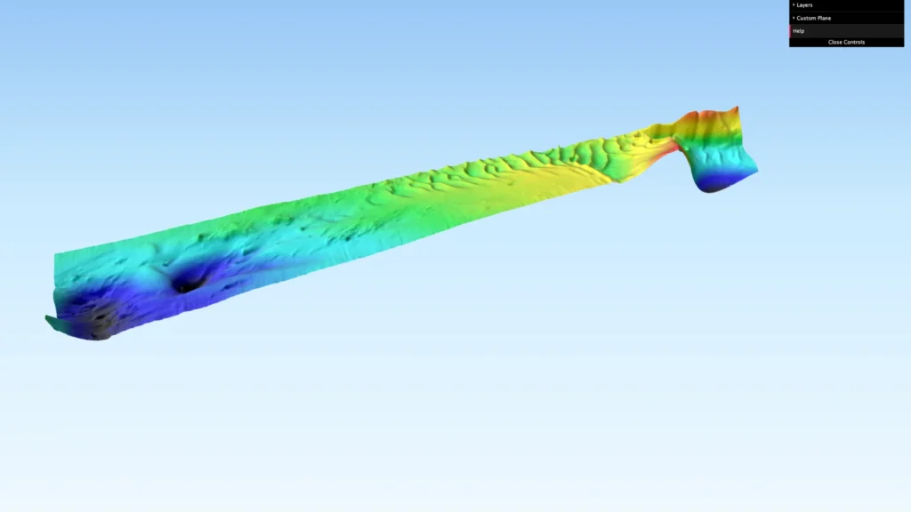
The resulting 3D bathymetric model displays underwater topography near the port’s industrial structures and dockside infrastructure. This model allows precise interpretation of water depth, object detection, and sediment variation in a busy harbor environment.
Hamburg docks bathymetric model interface
The interactive interface displays survey lines, computed bathymetry, quality layers, and dockside topographic features. Additionally, each element helps verify sensor stability and surface generation under constant motion and challenging conditions. Furthermore, these motion tests simulated real operational challenges surveyors face during port monitoring, dredging support, and asset inspection tasks. Engineers ensured that the data collection reflected real-world constraints.
Throughout the test, Horizon maintained exceptional stability and positioning integrity despite dynamic turns and wave-induced motion. As a result, the system ensured clean, reliable bathymetric output without visible drift or degradation.
Moreover, data processing included comparison with quality baselines and assessment of consistency across motion states. Consequently, results confirmed the effectiveness of Horizon’s motion compensation and sensor fusion algorithms. The web-based visualization of this 3D model offers users the opportunity to interact with the bathymetric dataset directly. In addition, the viewer can explore the Hamburg docks survey map with real-time overlays of quality indicators and trajectory tracking.
We invite hydrographers, engineers, and marine technology experts to explore the Hamburg Docks 3D bathymetric map. This visualization not only highlights the system’s performance in high-motion, real-world environments but also emphasizes the value of integrated navigation systems. Furthermore, these motion tests validate the Horizon system’s role in mission-critical hydrographic surveys. Even in challenging dockside operations, it consistently delivers precise, reliable data.
How to use the 3D bathymetric model visualization:
1 – One continuous click with 1 finger for a 360º move.
2 – Use trackpad 2 fingers gesture for zoom in/out
3 – Select all features you want to be presented (e.g. colors, survey line, etc.)
Get full access to other SBG Systems’ products test reports.