When every centimeter counts underground
Buried beneath fields, coastlines, and seabeds around the world lies a silent, decades-old threat: unexploded ordnance. For the geophysical survey teams tasked with finding it, precision it’s a professional obligation.
GapEOD, an Australian geophysical technology company, has built its entire business around solving this problem with precision.
Their UltraTEM electromagnetic detection platforms can sense metallic objects deep beneath the surface. But to be truly useful, that sensor data needs to know exactly where it’s pointing.
“Overall, the SBG solution matches our application constraints very well. It delivers the heading stability and accuracy we needed, and in day‑to‑day operation it performs reliably across all our platforms.” | Mari-Liis Tilk, Project Manager.

The problem with “close enough”
GapEOD’s UltraTEM systems are deployed in some of the most demanding geophysical survey environments imaginable like open plains, dense vegetation, offshore seabeds, and areas where GPS/GNSS signals are blocked or degraded. In these conditions, inconsistent heading performance from their previous attitude and heading unit was quietly undermining the quality of their data.
The geometry of the sensor platform was drifting, and there was no reliable way to compensate. Their clients, geophysicists and survey teams operating globally, expect actionable, precise data. “Close enough” wasn’t an option.
Two tools for two worlds
Rather than a single off-the-shelf fix, GapEOD needed a layered approach. For large vehicle-towed geophysical surveys in open terrain, they needed a high-accuracy inertial solution that could work tightly alongside RTK GPS corrections to deliver centimeter-accurate positioning.
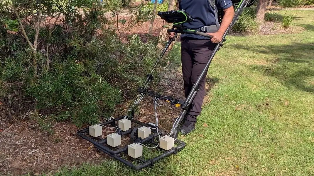
For man-portable systems in GPS/GNSS-occluded environments, dense urban areas, jungle canopy, underground, they needed something that could stand on its own heading authority.
SBG Systems’ Ellipse family answered both needs cleanly:
- Ellipse E (×3) — deployed on GapEOD’s vehicle-towed platforms in open areas, fused with Trimble R12 DGPS via RTK corrections for maximum absolute accuracy.
- Ellipse D (×3) — deployed on man-portable systems in GPS/GNSS-denied conditions, with dual-antenna GNSS heading providing a robust, independent orientation solution even when the sky is completely blocked.
Heading accuracy as a data quality lever
What changed after deploying the SBG Ellipse? The improvement was immediate and clear: heading reliability went from the weakest link in the system to a non-issue.
This matters more than it might seem. In electromagnetic geophysical surveying, the orientation of the sensor directly affects how subsurface anomalies are localized and mapped.
A few degrees of heading error consistently applied across a survey line means targets are systematically misplaced. GapEOD’s decision to upgrade their inertial systems was a geophysical survey data quality decision.
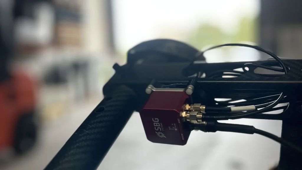
Built into the fabric of UltraTEM
Our Ellipse is the attitude and navigation backbone of every UltraTEM geophysical survey platform. Roll, pitch, and yaw data flow continuously from the Ellipse into the broader system, maintaining stable sensor geometry across the survey run.
Combined with Trimble DGPS where available, this creates a complete positioning pipeline that GapEOD’s geophysicist clients can trust.
A partnership built on responsiveness
Technology alone didn’t win GapEOD’s confidence. Early on, our team flew out to GapEOD’s site to assist with testing and calibration in person, a level of engagement that set the tone for the entire relationship.
When questions arose about optimizing heading accuracy or navigating the calibration workflow, our Australia and New Zealand support team were quick to respond. GapEOD gave us a perfect 5 out of 5 rating.
One honest note from GapEOD: some calibration procedures currently require physically removing the SBG unit, which adds steps to the field setup. It doesn’t block geophysical survey, but it’s the kind of friction worth solving as the integration matures.
What GapEOD values most
Three things stood out to GapEOD when asked what they love about SBG Systems:
- Product performance and build quality — the Ellipse delivers, geophysical survey after geophysical survey.
- Responsive troubleshooting support — a team that picks up the phone and solves problems fast.
- A genuinely useful YouTube channel — practical content that helps users get more from the hardware in real field conditions.
Protecting the world, one survey at a time
GapEOD leases its UltraTEM systems to geophysical survey companies worldwide. Their end users operate in conflict-affected zones, post-industrial sites, and offshore development corridors, places where the stakes of a missed target are severe.
The SBG Ellipse has become a trusted part of the technology stack that makes their surveys possible. Not because it’s the most visible component, but because when everything is working well underground, you rarely notice it, and that’s exactly the point.

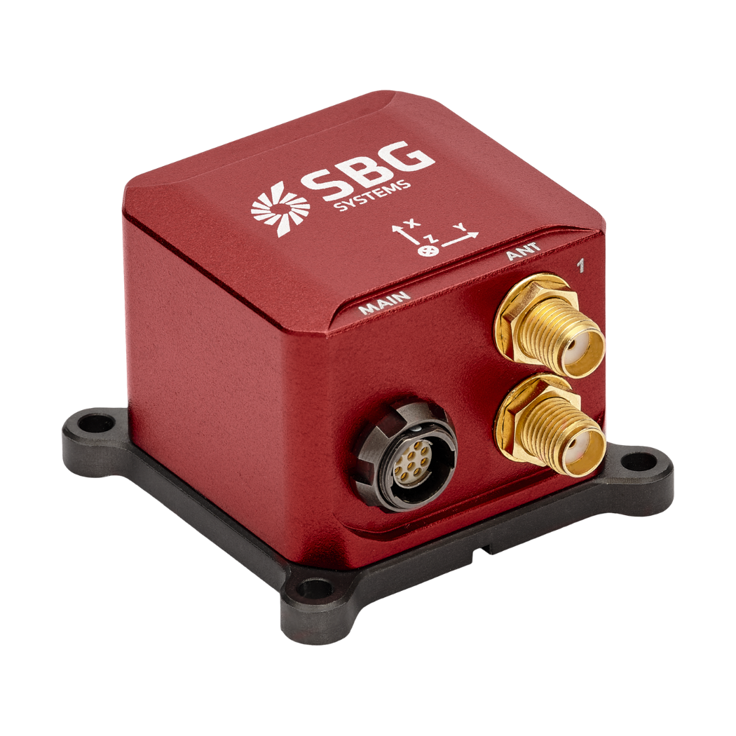
Ellipse-D
The Ellipse-D is a compact dual-antenna GNSS-aided inertial navigation system designed for applications that require reliable heading, attitude, and positioning in a small, easy-to-integrate form factor.
It is particularly well suited to dynamic environments where magnetic heading can be unreliable, making it a strong fit for mobile platforms, marine systems, and demanding industrial applications.
Key features include precise roll, pitch, and true heading output thanks to dual-antenna GNSS, robust performance in vibrating and high-dynamic conditions, and straightforward integration supported by comprehensive documentation.