Explore our solutions during extended GNSS outages ↓

GNSS frequencies

GNSS frequencies refer to the specific radio frequency bands used by satellite navigation systems to transmit signals to receivers on Earth. These signals carry essential information for calculating position, velocity, and time. Each GNSS constellation—such as GPS, GLONASS, Galileo, and BeiDou—uses its own set of frequencies.
GPS
First, the GPS constellation transmits on L1 (1560.000–1590.000 MHz), L2 (1212.000–1242.000 MHz), and L5 (1166.220–1186.680 MHz). The L1 band carries the primary civilian positioning signals, while L2 and L5 improve positioning accuracy, signal robustness, and ionospheric correction capabilities. Together, these frequencies enable reliable navigation across a wide range of applications.
GLONASS
GLONASS uses both Frequency Division Multiple Access (FDMA) and newer Code Division Multiple Access (CDMA) signals. Its FDMA services operate on G1 (1598.063–1605.370 MHz) and G2 (1242.938–1248.625 MHz), while the CDMA signals occupy G1a (1595.995–1605.995 MHz), G2a (1241.060–1255.060 MHz), and G3 (1191.795–1212.255 MHz). This hybrid architecture enhances interoperability with other global navigation satellite systems while maintaining compatibility with legacy receivers.
Galileo
The European Galileo system broadcasts on E1 (1563.144–1587.696 MHz), E5a (1166.220–1186.680 MHz), E5 AltBOC (1166.220–1217.370 MHz), E5b (1196.910–1217.370 MHz), and E6 (1258.290–1299.210 MHz). Several of these signals overlap with GPS frequencies, facilitating multi-constellation positioning while providing high-accuracy commercial and safety-of-life services.
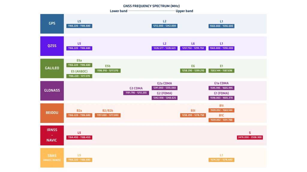
Note: Values represent the lower and upper limits of each band.
BeiDou
China’s BeiDou navigation system transmits on B1I (1559.052–1563.144 MHz), B1C (1559.052–1591.788 MHz), B2a (1166.220–1186.680 MHz), B2/B2b (1197.000–1217.000 MHz), and B3I (1258.290–1278.750 MHz). These multiple frequency bands improve positioning accuracy, enhance signal availability, and ensure interoperability with other GNSS constellations.
QZSS
Japan’s Quasi-Zenith Satellite System (QZSS) complements GPS coverage over the Asia-Pacific region by transmitting on L1 (1573.420–1577.420 MHz), L2 (1226.577–1228.623 MHz), L5 (1166.220–1186.680 MHz), and L6 (1257.750–1299.750 MHz). The L6 signal is dedicated to high-precision augmentation and correction services.
NavIC
India’s NavIC (IRNSS) broadcasts on L5 (1164.450–1188.450 MHz) and the S-band (2476.030–2508.300 MHz). Unlike other global constellations, NavIC uniquely employs the S-band, providing robust regional positioning and navigation services across India and surrounding regions.
SBAS
Finally, Satellite-Based Augmentation Systems (SBAS) such as WAAS and EGNOS transmit correction messages on L1 (1574.397–1576.443 MHz) and L5 (1166.220–1186.680 MHz). These augmentation signals improve positioning accuracy, integrity, and availability by broadcasting real-time corrections for GNSS users. Additionally, dedicated L-band correction services (1539.000–1559.000 MHz) are widely used to deliver Precise Point Positioning (PPP) and other high-accuracy GNSS correction data worldwide.
Dual- or multi-frequency receivers use two or more bands to correct signal errors. For example, they mitigate ionospheric delays and improve accuracy. This makes them suitable for high-precision applications. Moreover, modern GNSS receivers combine signals from multiple constellations. This multi-constellation capability enhances positioning reliability, especially in obstructed environments.
Signal modulation and coding also vary across frequencies. Each frequency carries unique codes that help distinguish between satellites. These differences improve tracking performance and error correction.
Do you have questions?
What does GPS stand for?
GPS (Global Positioning System) is a satellite-based navigation system that provides location, velocity, and precise time information anywhere on Earth, under all weather conditions, as long as there is an unobstructed line of sight to four or more GPS satellites.
Developed and maintained by the United States Department of Defense, GPS consists of three segments:
- Space Segment: A constellation of at least 24 satellites orbiting Earth.
- Control Segment: Ground stations that monitor, control, and maintain the satellites.
- User Segment: GPS receivers (in smartphones, cars, aircraft, ships, etc.) that compute position using signals from the satellites.