
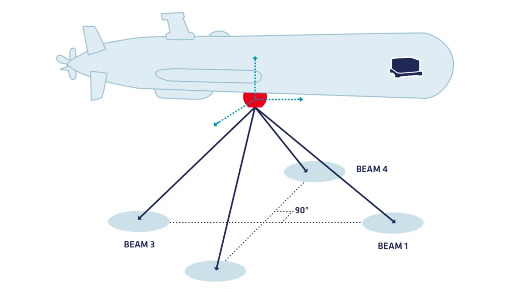
A Doppler Velocity Log (DVL) is an acoustic sensor used to measure the velocity of an underwater vehicle relative to the seafloor or water column. It operates by emitting sound waves from transducers angled downward or outward. These acoustic pulses reflect off the seabed or suspended particles in the water and return to the sensor. The system then calculates the Doppler shift—the change in frequency between the emitted and received signals—to determine the vehicle’s velocity in three dimensions (surge, sway, and heave).
DVLs are essential for underwater navigation, especially where GNSS signals are unavailable. By integrating velocity over time, DVLs help estimate the position, track motion, and assist in maintaining a stable course. They are commonly used in autonomous underwater vehicles (AUVs), remotely operated vehicles (ROVs), and manned submersibles. These sensors are also widely used in applications such as oceanographic research, subsea surveying, offshore infrastructure installation, and pipeline inspection. High-precision DVLs often integrate with inertial navigation systems (INS) to improve accuracy and robustness, especially in challenging environments.
Overall, a DVL provides critical navigation data, enabling reliable operation and maneuvering of underwater systems in both shallow and deep-sea missions.
How DVL works ?
To understand the significance of DVL sensors, it is important to first explore what they are and how they function. Essentially, a DVL sensor is an acoustic navigation tool that measures the speed of an underwater vehicle relative to the seafloor or water column. It works by emitting sound waves from multiple transducers angled downward.
The sensor emits waves that bounce off the seabed or particles in the water and then return, allowing it to analyze the frequency shift between the emitted and received signals—the Doppler shift—to determine velocity.
Sensors architecture
Diving deeper into their architecture, DVL sensors include several critical components. The transducers serve as both emitters and receivers of acoustic pulses, forming the foundation of the measurement process. The onboard processor is responsible for interpreting the Doppler shift and calculating the resulting velocity vectors. Additionally, a durable housing protects all internal electronics from harsh underwater environments, ensuring long-term operation and reliability. Finally, a data interface links the DVL to external systems, such as an inertial navigation system (INS) or onboard data loggers, enabling seamless integration into complex underwater platforms.
Moreover, DVL sensors do more than just measure speed—they play an integral role in comprehensive underwater navigation solutions. DVL systems estimate a vehicle’s position by integrating velocity data collected continuously over time. This is especially useful for autonomous underwater vehicles (AUVs) and remotely operated vehicles (ROVs), which rely on such sensors to maintain accurate trajectories during missions.
DVLs benefits in navigation
In addition to navigation, DVLs are indispensable in underwater surveying and mapping. DVL sensors provide real-time, high-resolution velocity data. This data supports precise tracking and positioning. Precise positioning is essential for seabed mapping, infrastructure inspection, and environmental monitoring. Surveyors use DVL data to construct accurate bathymetric maps. They also locate subsea assets with this information. Additionally, they monitor sediment movement across the ocean floor.
Furthermore, DVL sensors find important applications in oceanographic research. Scientists use them to measure water current velocities, analyze sediment transport patterns, and study marine animal behavior. By placing DVL-equipped platforms in strategic locations, researchers can gather valuable long-term data sets that contribute to our understanding of marine dynamics and climate-related changes.
Doppler Velocity Log sensors applications
Transitioning to industrial uses, DVL sensors are widely used in the offshore oil and gas sector. Here, accurate navigation and positioning are paramount, especially when deploying and servicing subsea infrastructure such as pipelines, wellheads, and risers. DVL sensors enable precise control of underwater vehicles performing complex tasks at significant depths, enhancing both safety and operational efficiency.
From a technological standpoint, several key advancements ensure the performance and reliability of modern DVL systems. High-frequency acoustic transducers offer exceptional resolution for short-range tasks, while lower frequencies enable longer-range measurements. Sophisticated signal processing algorithms further enhance performance by filtering out environmental noise and compensating for changes in salinity, temperature, and pressure—factors that significantly impact sound propagation underwater.
Additionally, many DVL sensors operate in tandem with INS and GNSS systems. When combined, these technologies deliver robust navigation capabilities that are resistant to signal loss and environmental disruption. Such redundancy is critical during long-duration missions or in deep-sea conditions where external positioning references are unavailable.
Importantly, regular calibration and environmental compensation procedures are essential to maintain measurement accuracy. Technicians must periodically adjust the sensor to account for shifting conditions, ensuring data integrity across a wide range of missions and operating environments.
In conclusion, DVL sensors have become a cornerstone of modern underwater operations. They enable reliable navigation, support scientific exploration, improve industrial workflows, and enhance the precision of subsea mapping. As acoustic technology and data processing continue to advance, DVL sensors continue to evolve and remain indispensable tools for unlocking the mysteries of the ocean and supporting critical infrastructure beneath the waves.
Explore other DVL applications
Explore how DVL technology supports a wide range of marine operations beyond standard navigation. From unmanned surface vessels (USVs) to autonomous underwater vehicles (AUVs), they deliver precise velocity and positioning data critical for mission success. Whether used for subsea infrastructure inspection, seabed mapping, or scientific research, these sensors ensure reliable performance in demanding surface and underwater environments.